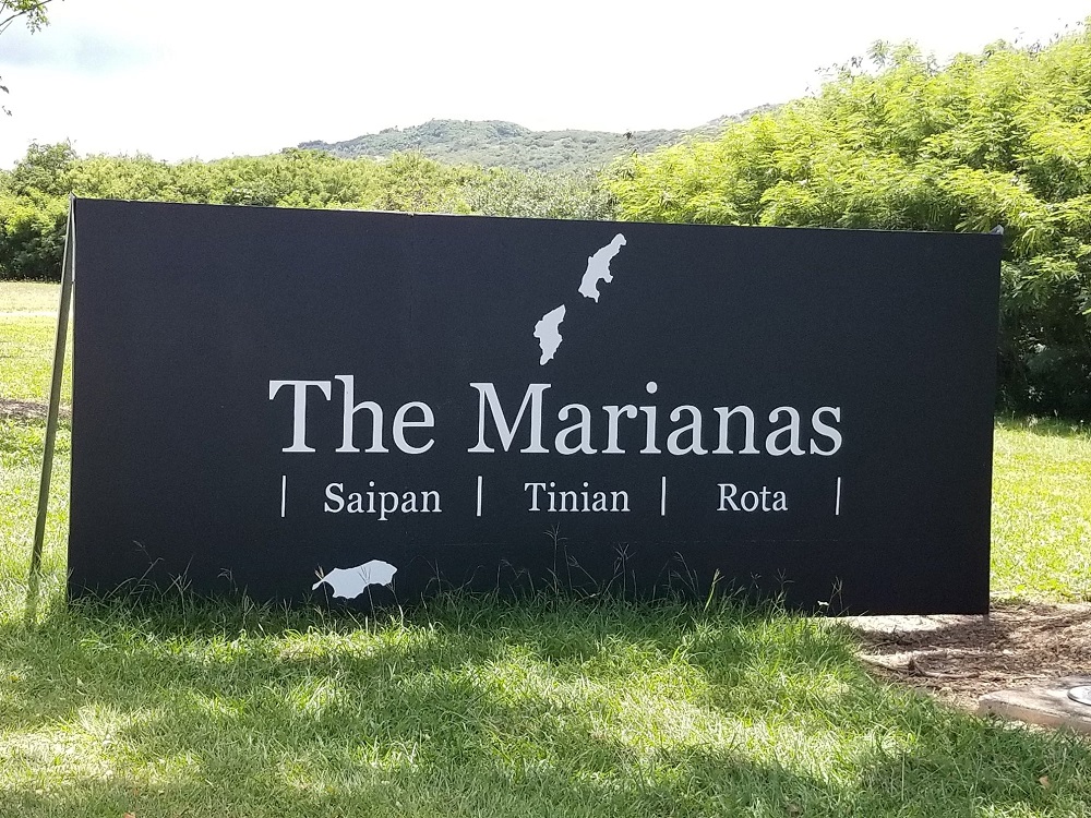
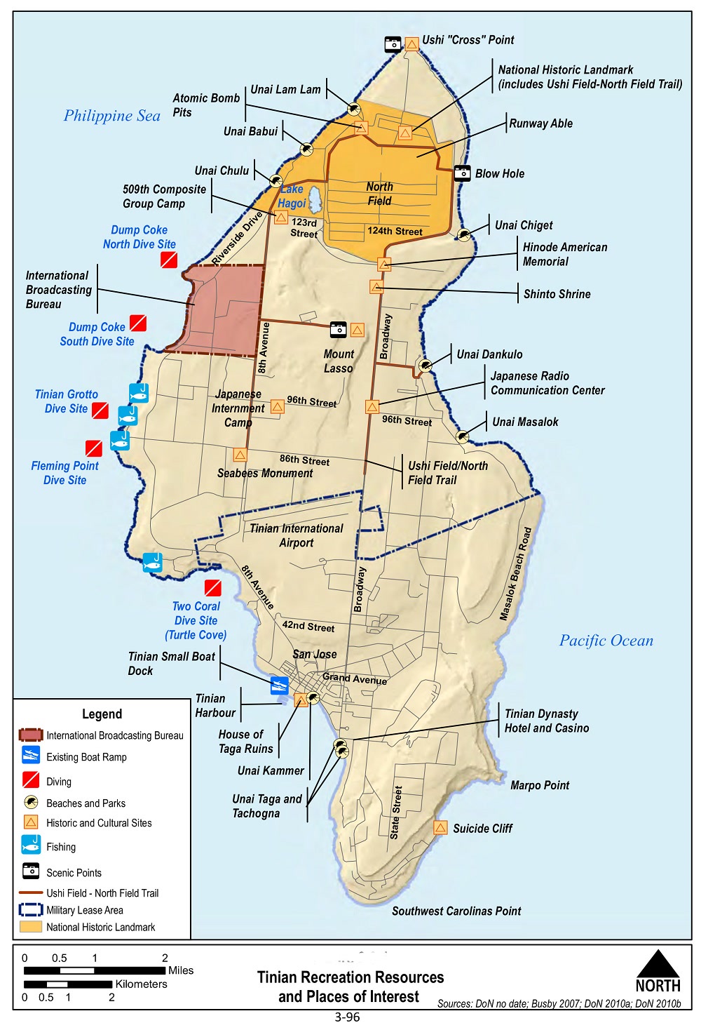
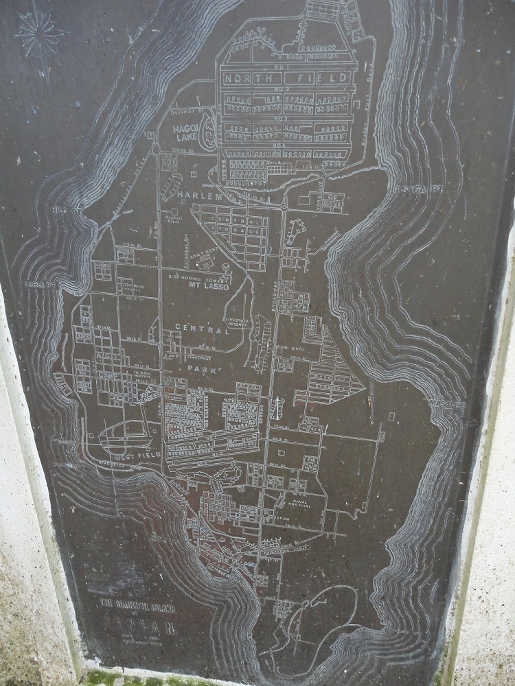
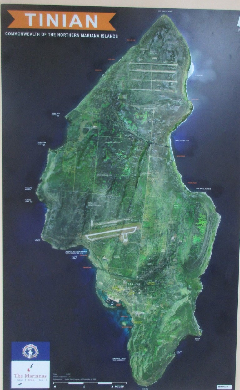
 Map & Suggested Tour Route
(Slide 1 of 60 )(Swipe page or use arrows to navigate)
Watch a video of the flight to Tinian!
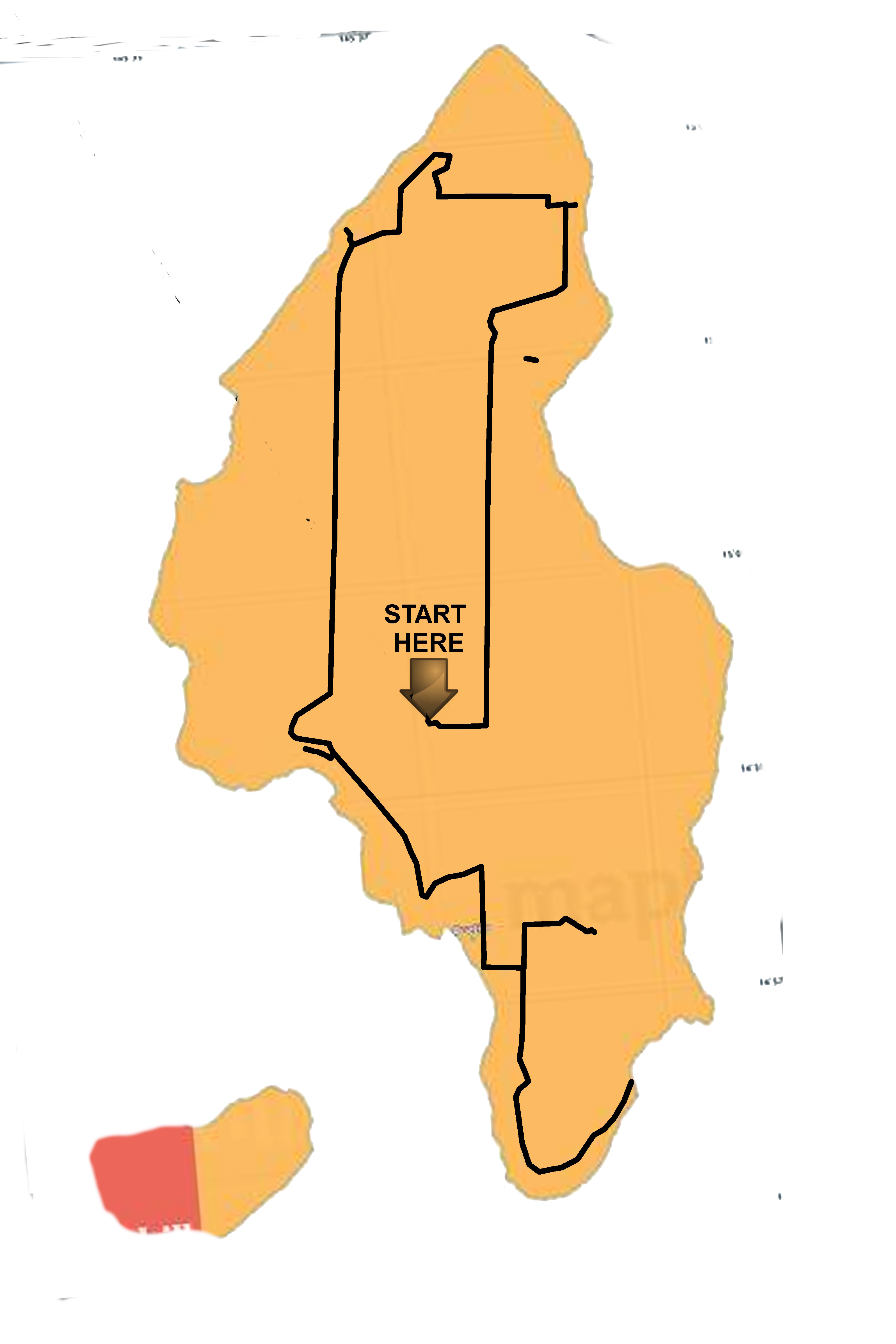
Simplified Tour Route
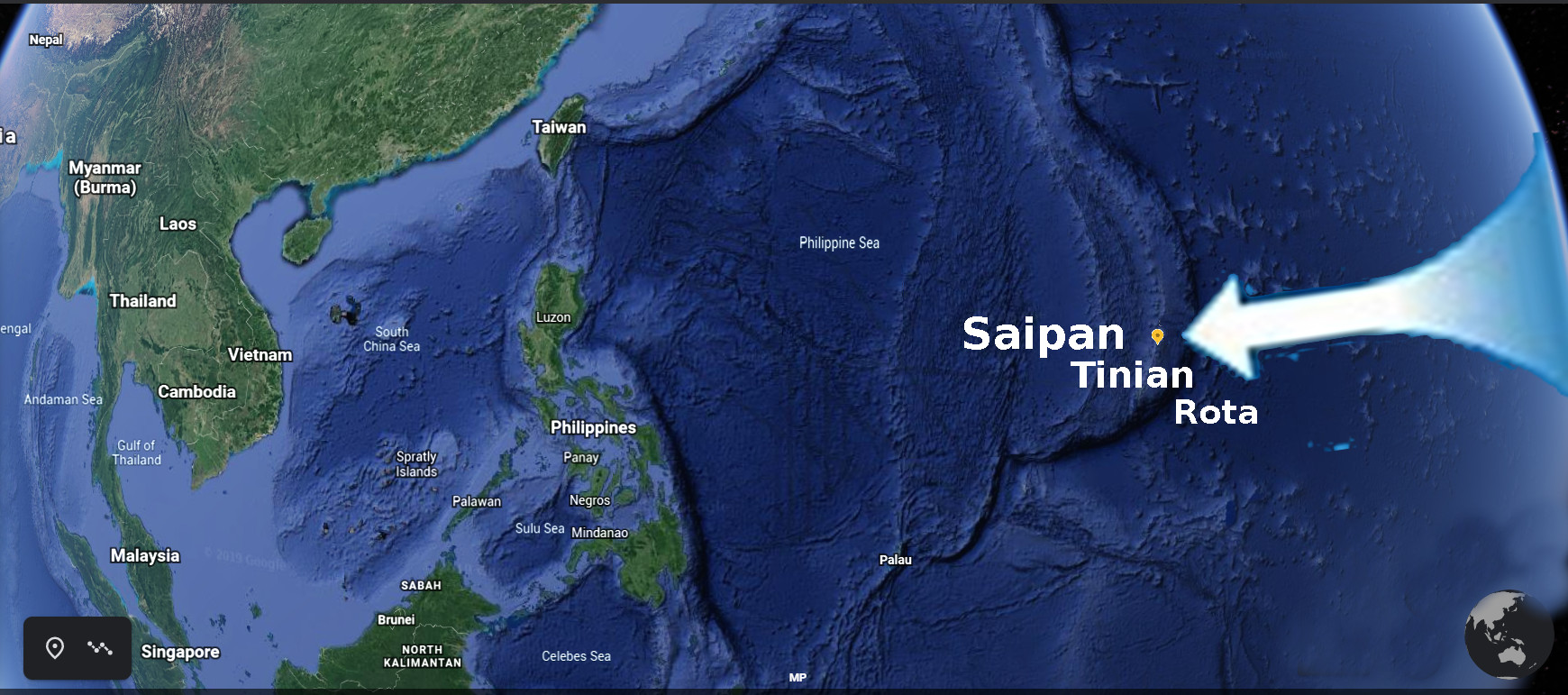
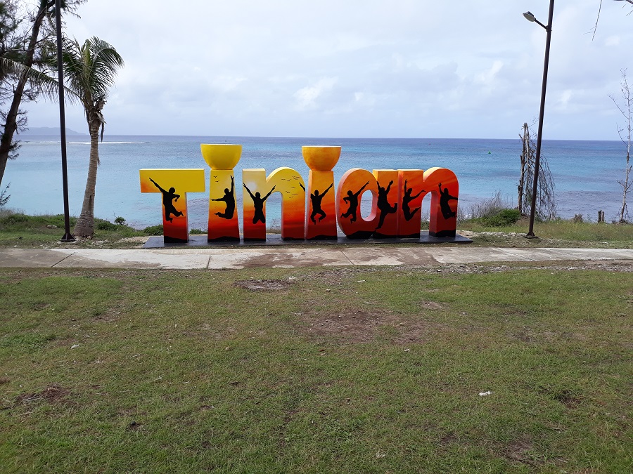
Where is Tinian?
Located in the Western Pacific, a short flight from Guam and three hours from Japan, the Commonwealth of the Northern Mariana Islands (CNMI) is a popular tourist destination rich in history, culture and natural resources. Tinian is the second largest and most populated of the 15 islands making up an archipelago that stretches 400 miles (north to south) along the edge of the Marianas Trench.
Your Tour!
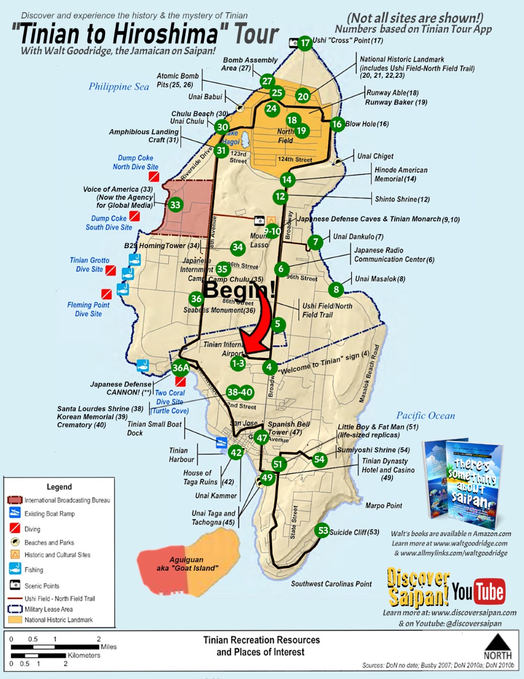
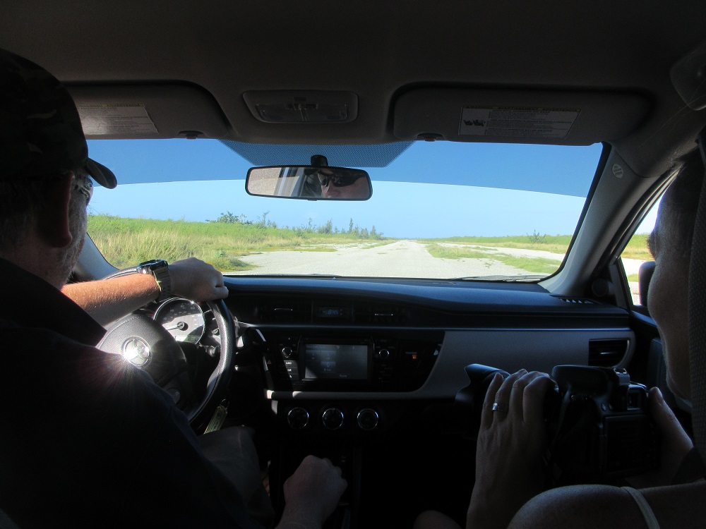
By the time your "Tinian to Hiroshima" Tour is over, you'll have covered almost every corner of this unique island! It will take between 5 and 6 hours and you'll cover roughly 50 miles of road and off-road. Yes, there's a lot to learn about this historic island as you discover Tinian!
Bonus Photos by Richard Kirby (UK)
In related news: Richard Kirby, a tour client, was gracious enough to provide photos from his post-tour visit to the National Air and Space Museum, Steven F. Udvar-Hazy Center, in Chantilly, Virginia.
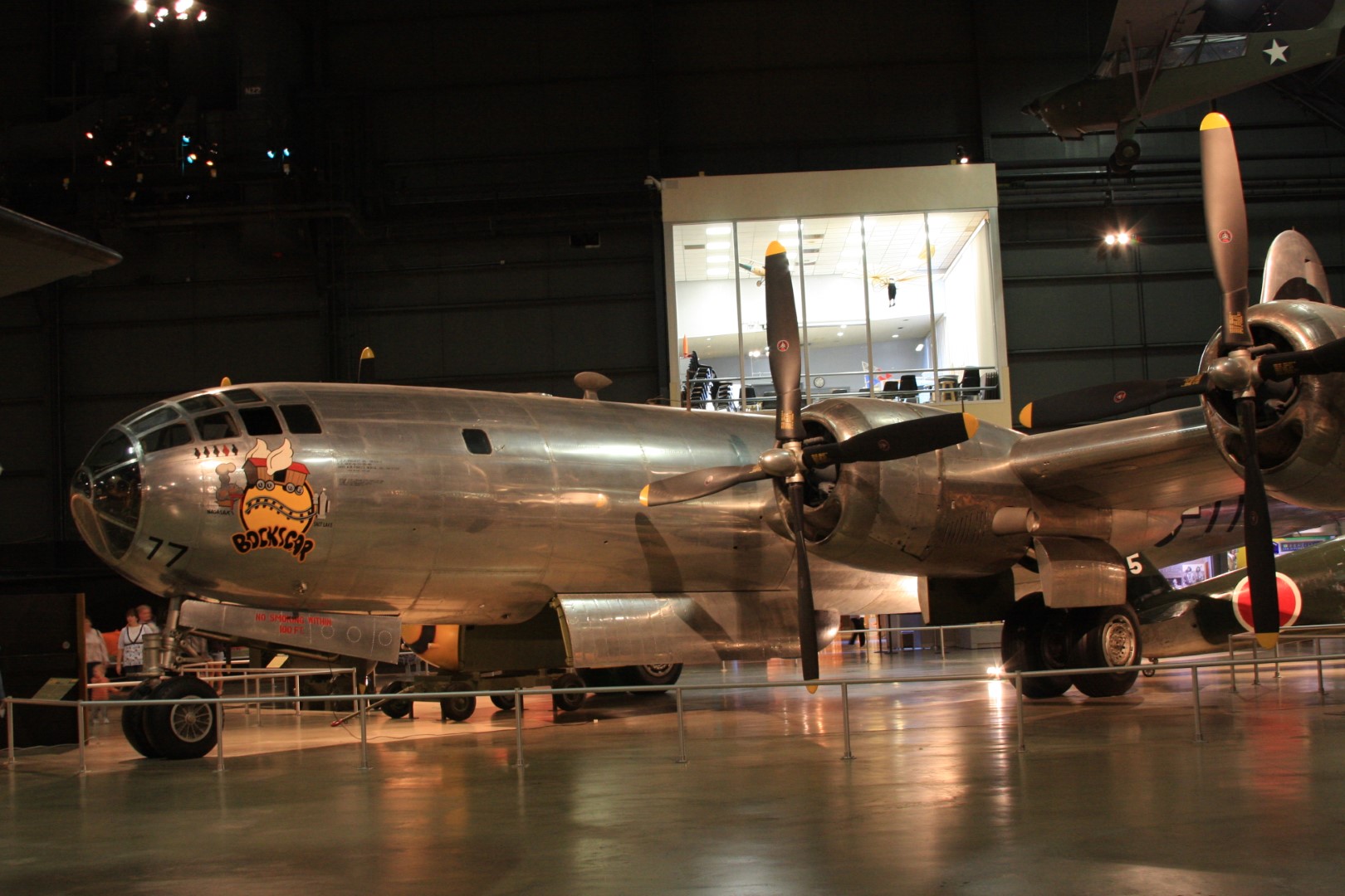 © Richard Kirby
 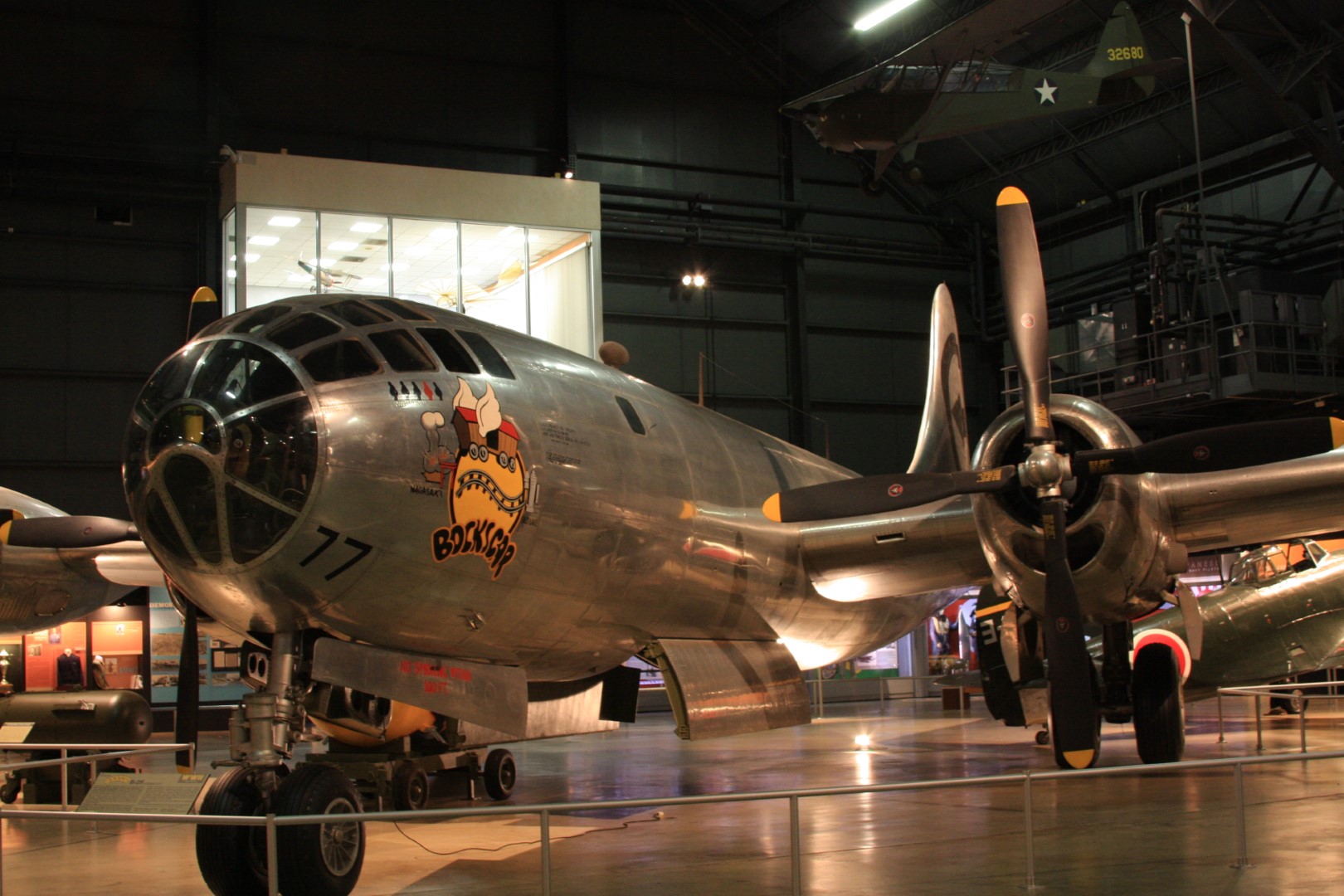 © Richard Kirby
 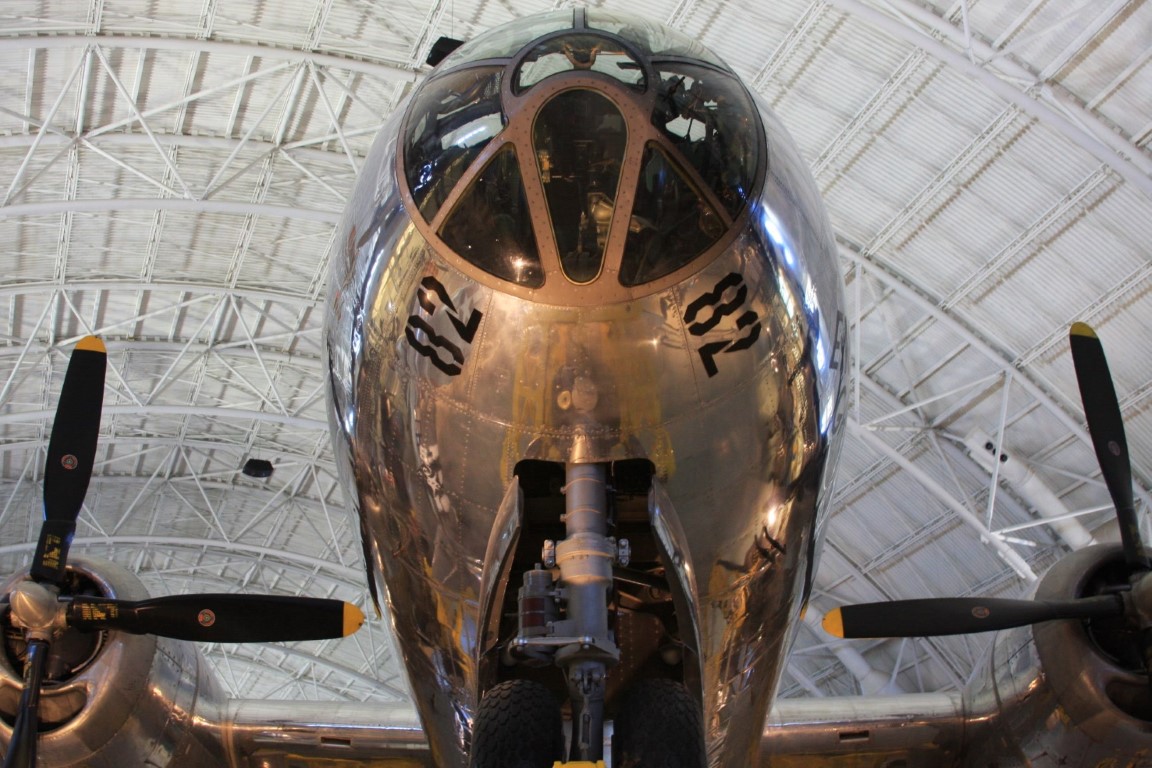 © Richard Kirby
 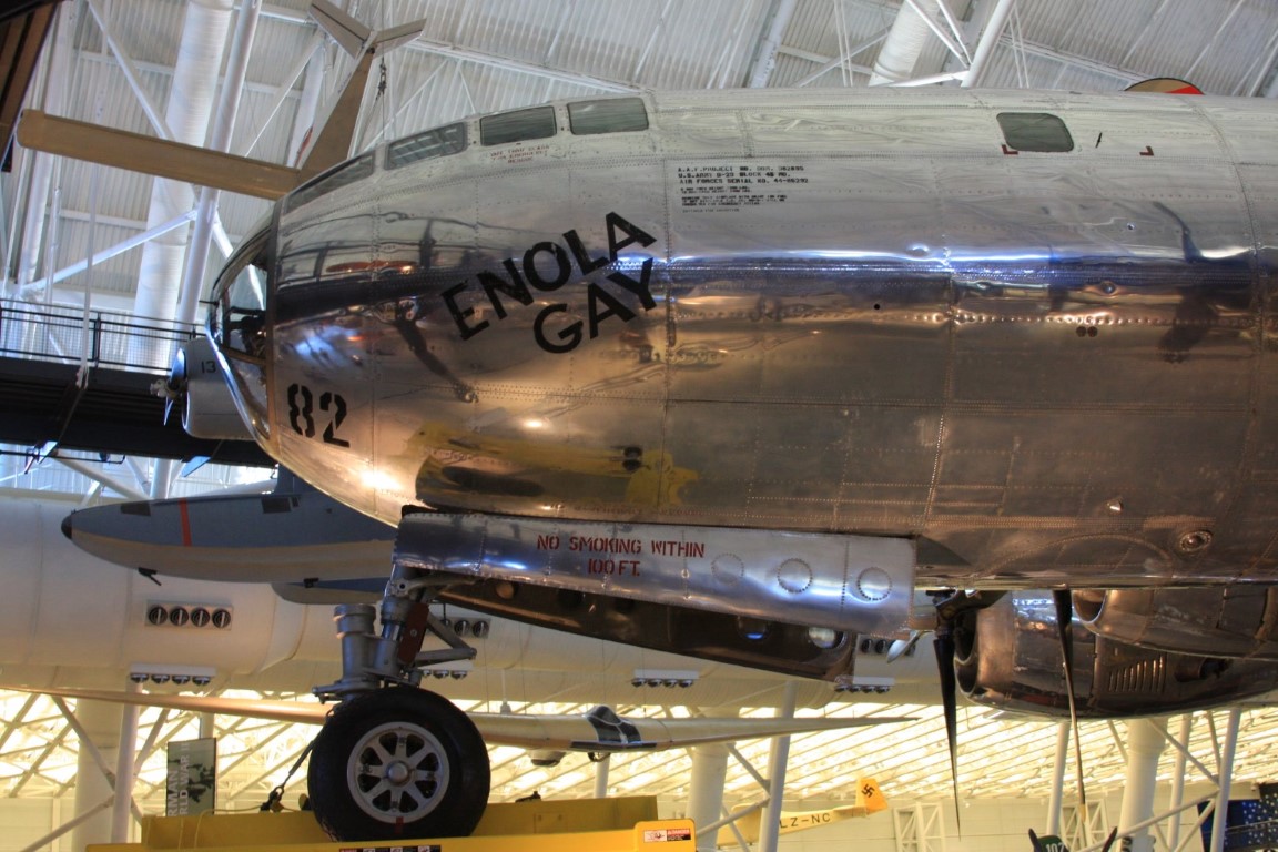 © Richard Kirby
 Sources: Dept of the Navy, MVA, HPO,Wikipedia, Richard Kirby
Categories: World War II
Airport Taga Sculpture
(Slide 2 of 60 )(Swipe page or use arrows to navigate)
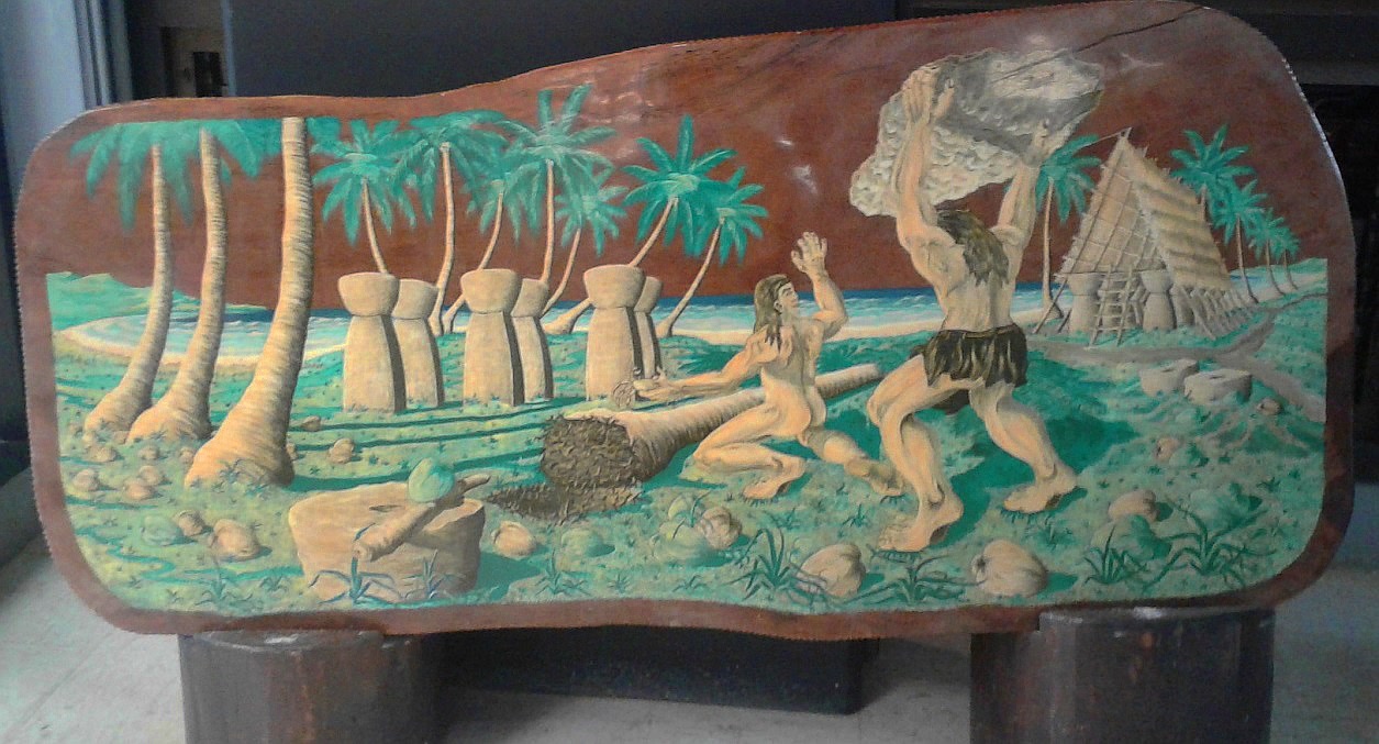
On your way through the Tinian airport terminal, be sure to find and snap a photo of this sculpture featuring Chamorro King Taga. It was created by resident and artist John David Diaz. You'll learn more about the legend depicted in this story later in your tour! [photo: Cassandra Randolph]
Take a closer look!
Categories: Chamorro/Carolinian/Pacific Culture
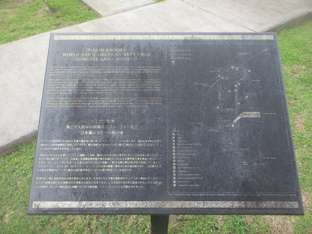
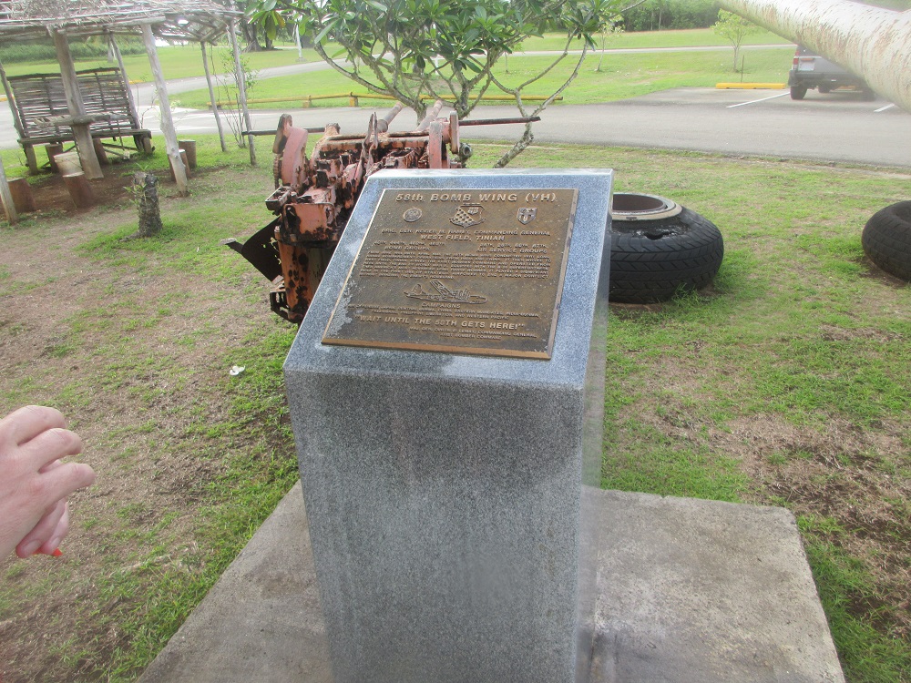
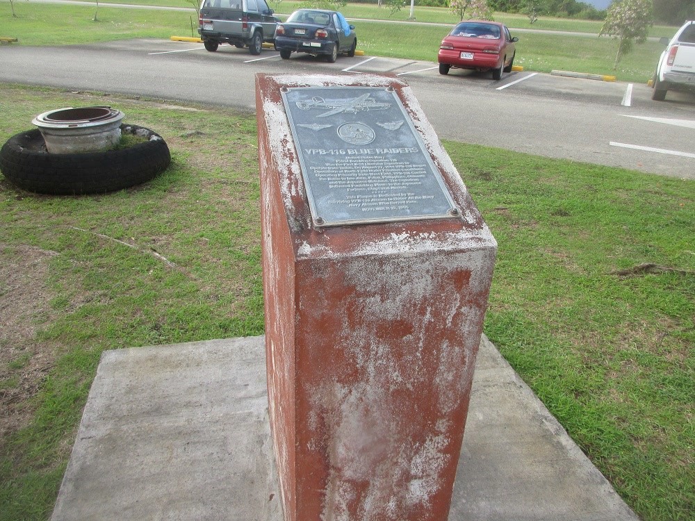
Airport Plaque & B-29 Tires
(Slide 3 of 60 )(Swipe page or use arrows to navigate)
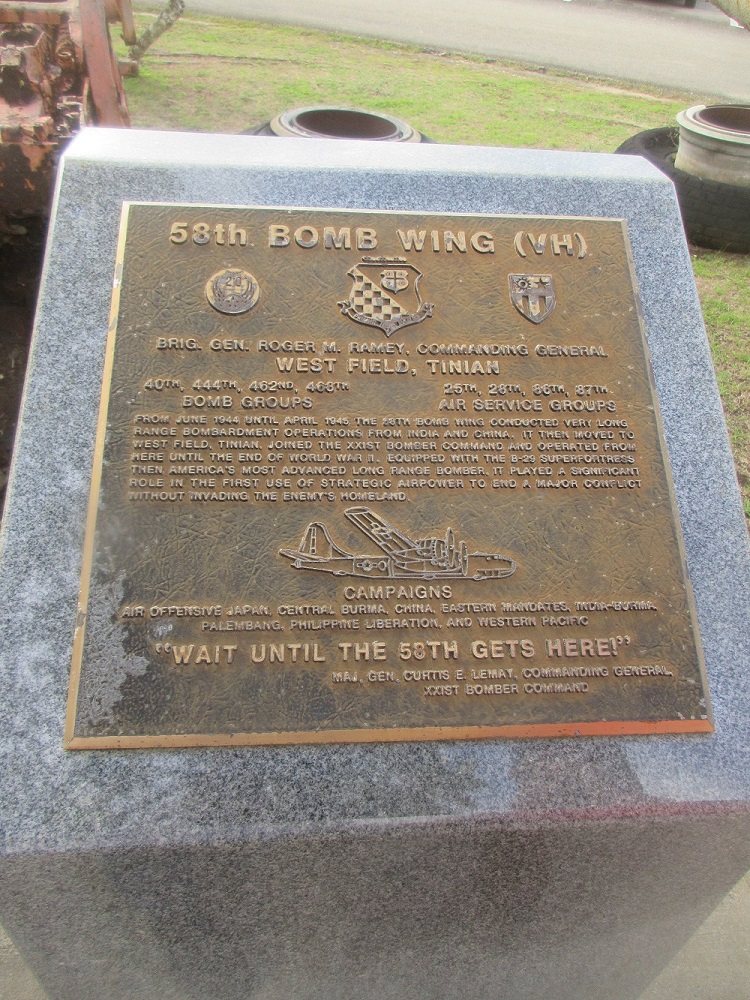
Take a look inside!
Tinian Airport
World War II American West Field
Japanese Kahit Airfield
Tinian Airport is located at historic West Field, a World War II American airfield. Today, the United States Navy leases the area north of the airport for military training. The area is open to the public when it is not being used for military activities.
When American forces invaded Tinian on July 24, 1944, there were four Japanese airfields on the island. One of these was Kahit Airfield, located near this area. After the capture of Tinian, U.S. Seabee battalions constructed two massive airfields; one at the north point of the island and the second here in this area. Called West Field, this airfield was operational by March 1945 and was used by the 58th Bomb Wing of the 20th Air Force. West Field had two runways constructed for the B-29 Superfortress and a third runway for smaller planes. This third runway is now used by Tinian Airport.
Around this area are artifacts of war, including a Japanese anti-aircraft machine gun and a naval gun that came from a firing position hidden in caves southeast of Tinian Town (now San Jose Village). This is one of the guns that inflicted severe damage on the battleship Colorado and the destroyer Norman Scott during the first day of the battle of Tinian. It is a British-made, (155mm) six-inch (155mm) gun, manufactured in 1905.
Categories: World War II
"Welcome to Tinian" Sign
(Slide 4 of 60 )(Swipe page or use arrows to navigate)
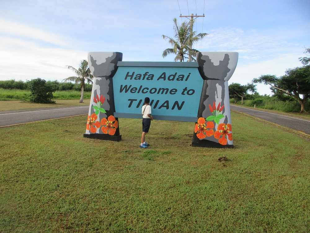
Very few people on the planet will ever set foot on this historic island! You can't fly all the way here--to one of the most significant destinations in world history--and not take a photo next to the sign! Do it! You won't regret it! Impress your friends and family!
Let's go up close!
Military Lease Area
(Slide 5 of 60 )(Swipe page or use arrows to navigate)
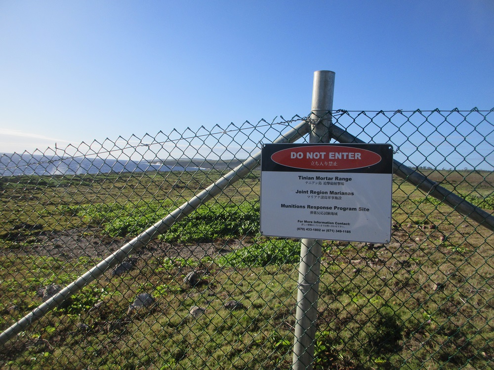
The Department of the Navy (DoN) retains control of lands encompassing the North Field National Historic Landmark based on a 50-year lease agreement with the CNMI (the landowner). This agreement has been in place since 1983. The sites are accessible to the public, except during certain periods of military training. The DoN provides a 45-day advanced notice to CNMI agencies when such military training is scheduled on Tinian. Some areas of the lease area (i.e., Mortar Testing Area) are permanently off limits to the public and signs are conspicuously posted remind the public.
Japanese Radio Communications Center
(Slide 6 of 60 )(Swipe page or use arrows to navigate)
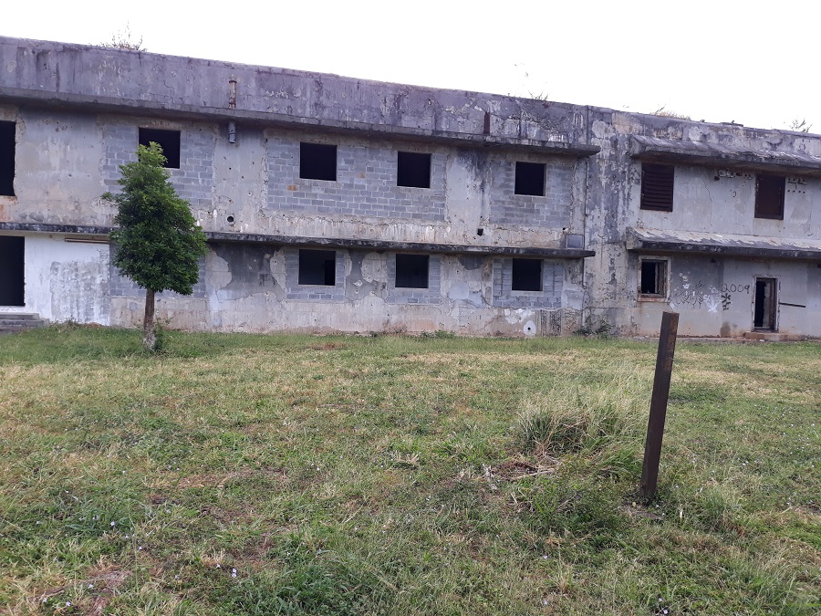
This is the Japanese Air Communications Building. It served the purpose of inter-island communication for the Japanese garrison on Tinian.
Step inside, take a look around. Head up to the second floor (be mindful of metal shards when climbing and descending the steps!)
Local Lore: Over the years, this building has been used by residents for a number of other purposes including as a typhoon shelter and even a livestock slaughterhouse!
Let's take a look inside!
(Video may be muted. Unmute to listen.);?> Unai Dangkulo Trail
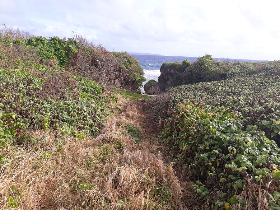
(Slide 7 of 60 )(Swipe page or use arrows to navigate)
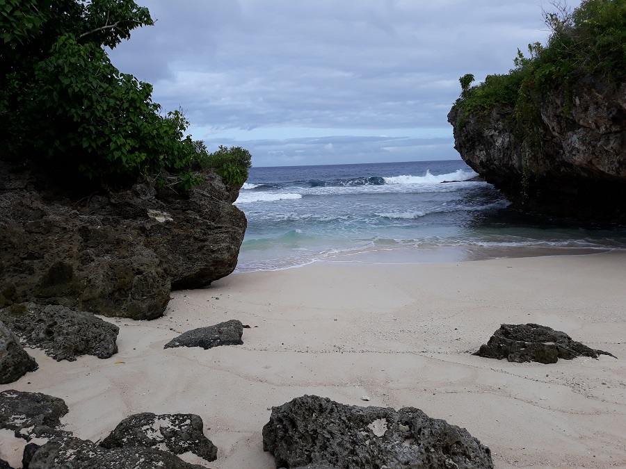
 Unai Dangkulo (Unai=beach; Dangkulo = long)
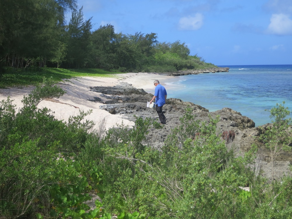
Situated on the east coast, Unai Dangkulo is the largest beach on Tinian and has a continuous reef crest spanning the entire length of the beach. Unai Dangkulo comprises at least 10 beaches over a distance of 4,921 feet (ft) (1.5 km). [Chamorro.com; Guam and CNMI Military Relocation Final EIS (July 2010)]
Unai Masalok Trail
(Slide 8 of 60 )(Swipe page or use arrows to navigate)
 Unai Masalok Trail
Located just south of Tinian's Long Beach, Unai Masalok consists of three small pocket beaches. The first of the pocket beaches can be reached at the end of a steep, very overgrown trail leading through the brush from the parking area. The next two pocket beaches can be reached by wading through shallow water at high tide. The parking area is in a shady forest area and contains signs describing an ancient latte stone site. Artifacts from World War II can also be seen nearby. [DCRM.gov.mp]
Japanese Defense Caves
(Slide 9 of 60 )(Swipe page or use arrows to navigate)
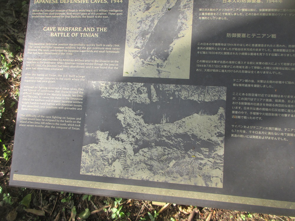
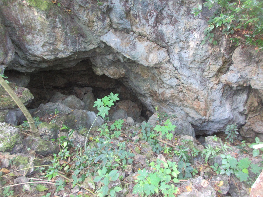
Before the American invasion of Tinian in World War II, U.S. military intelligence identified two dual-purpose, dual-mount guns at this position. These guns would have been trained on Unai Dangkulo, the beach to the east.
Cave Warfare and the Battle of Tinian
This Japanese defensive position was probably quickly built in early 1944. The caves sheltered Japanese soldiers, but the gun positions were never finished. The caves overlooked the Japanese sugarfields and small farmsteads that had been developed in the 1930s.
This position was pounded by American artillery prior to the invasion on the beaches to the northwest. When American troops moved through the area on July 27, 1944, the position had been abandoned, and it was found that the guns had never been emplaced.
After the battle of Tinian, the U.S. built a large military storage complex to the north where the sugarcane had once grown.
Although no fighting occurred at these caves, they are typical of conditions that characterized the difficult firefights of the Mariana Islands, Iwo Jima, and Okinawa. In caves like these in the limestone cliffs at the southern end of the island, Japanese soldiers fought hand-to-hand battles with American troops who assaulted cave positions with grenades and flame-throwers.
The difficulty of the cave fighting on Saipan and Tinian would later be eclipsed by the battle on the island of Iwo Jima, 600 miles to the north, which took place seven months after the conquest of Tinian. [Wayside]
Let's look inside the caves!
Tinian Monarch
(Slide 10 of 60 )(Swipe page or use arrows to navigate)
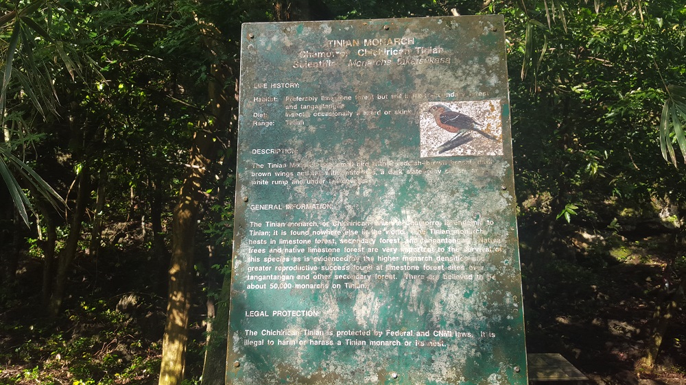
Tinian Monarch
Chamorro: Chichirican Tinian
Scientific: Monarcha takatsukasae
Life History:
Habitat: Preferably limestone forest but will inhabit secondary forest and tangan tangan.
Diet: Insects, occasionally a lizard
Range: Tinian
Description:
The Tinian Monarch is a small bird with a reddish-brown breast, dark brown wings and tail, a dark slate-gray white rump and under tail
General Information:
The Tinian monarch, or Chichirican Tinian in Chamorro, is endemic to Tinian; it is found nowhere else in the world. The Tinian monarch nests in limestone forest, secondary forest and tangantangan. Native trees and native limestone forest are very important to the survival of this species as is evidenced by the higher monarch densities and greater reproductive success found at limestone forest sites over tangantangan and other secondary forest. There are believed to be about 50,000 monarchs on Tinian.
Legal Protection:
The Chichirican Tinian is protected by Federal and CNMI laws. It is illegal to harm or harass a Tinian monarch or its nest.
Bird Watching
(Slide 11 of 60 )(Swipe page or use arrows to navigate)
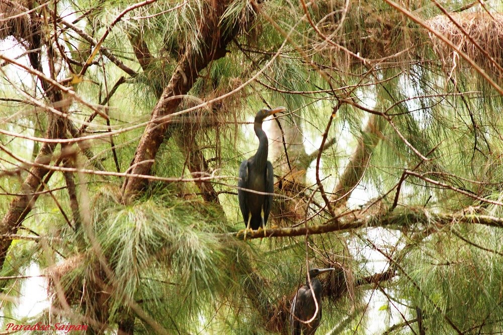
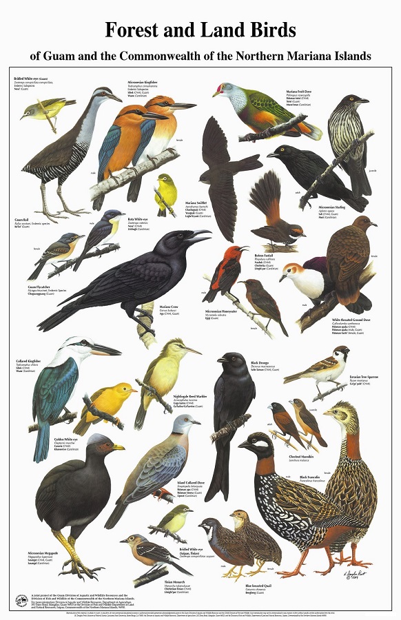
Speaking of the Tinian Monarch, keep your eyes open! Tinian, like Saipan, is home to a variety of sea and land birds. During your tour, you're likely to hear then see the unmistakable bright blue and white Kingfisher or the Pacific Reef Heron while you're on the beach!
Categories: Nature
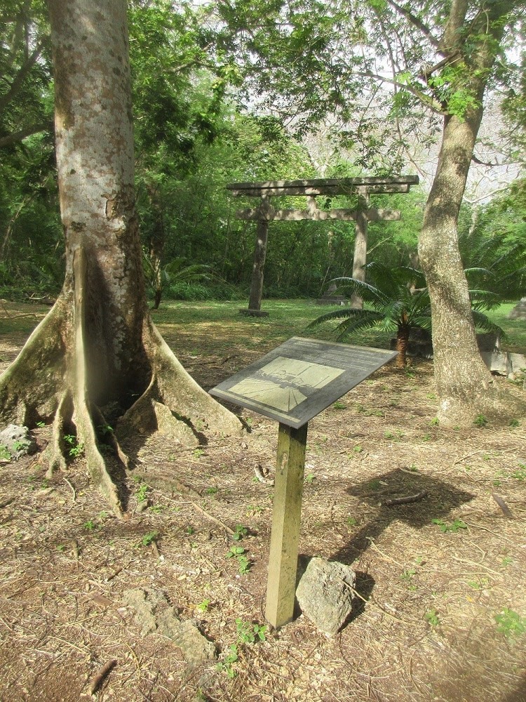
NKK Shinto Shrine
(Slide 12 of 60 )(Swipe page or use arrows to navigate)
The NKK Shinto Shrine was built next to a spur of the sugar railroad, and its name suggests that it was constructed by the sugar company, the Nan'yo Kohatsu (or NKK), the South Seas Development Company. A date on one of the arches indicates that it was built in 1941.
The path to the altar leads through two torii, Shinto gates. These gates mark the hallowed ground of the shrine and may symbolize wild trees, suggesting the origins of Shinto in the spirits of nature. The style of the torii here is known as "Myojin," referring to the enlightened Kami [divine spirits of Shinto], with the characteristic upward curve of the top bars. Myojin-Torii was a popular torii style in Japan during the early 1900s. It is said to have originated at the Kamo Shrines of Kyoto, and is best known at the Meiji Shrine of Tokyo.
Japanese development on Tinian started around 1926 when the NKK expanded its operations from Saipan to Tinian. Tinian was ideally suited for sugarcane. Within ten years, the island had become a giant plantation, with about 80 percent of the island under sugarcane cultivation. Tinian had also become an island of Japanese citizens and Japanese culture.
Walk through the torii!
Okinawan House
(Slide 13 of 60 )(Swipe page or use arrows to navigate)
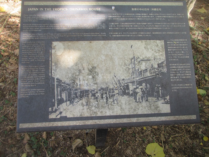
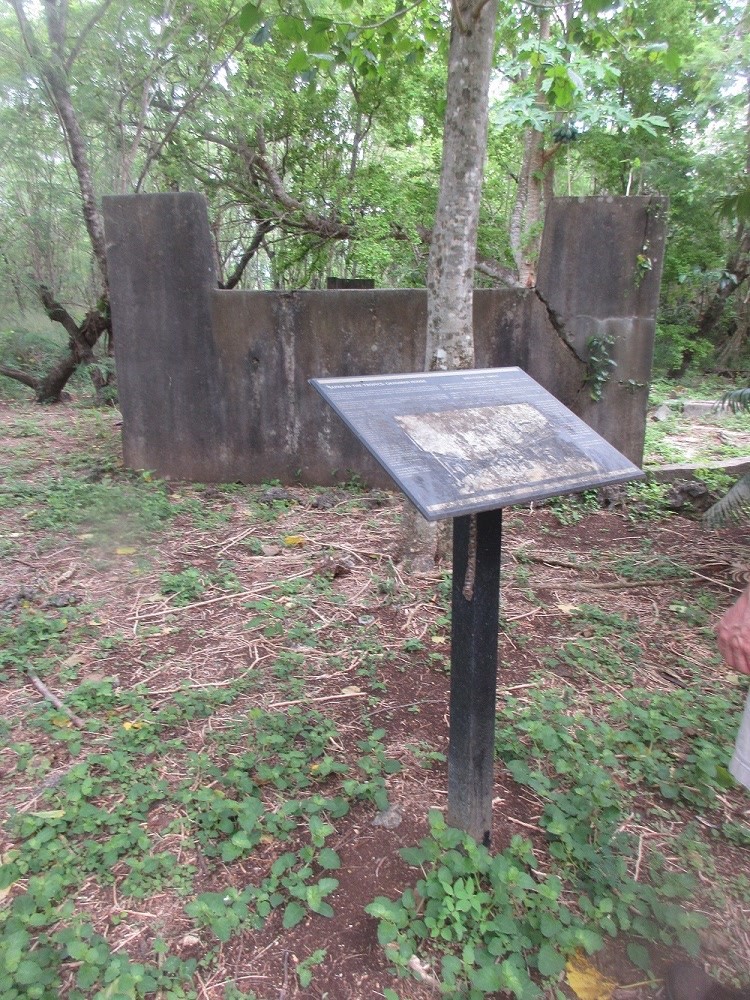
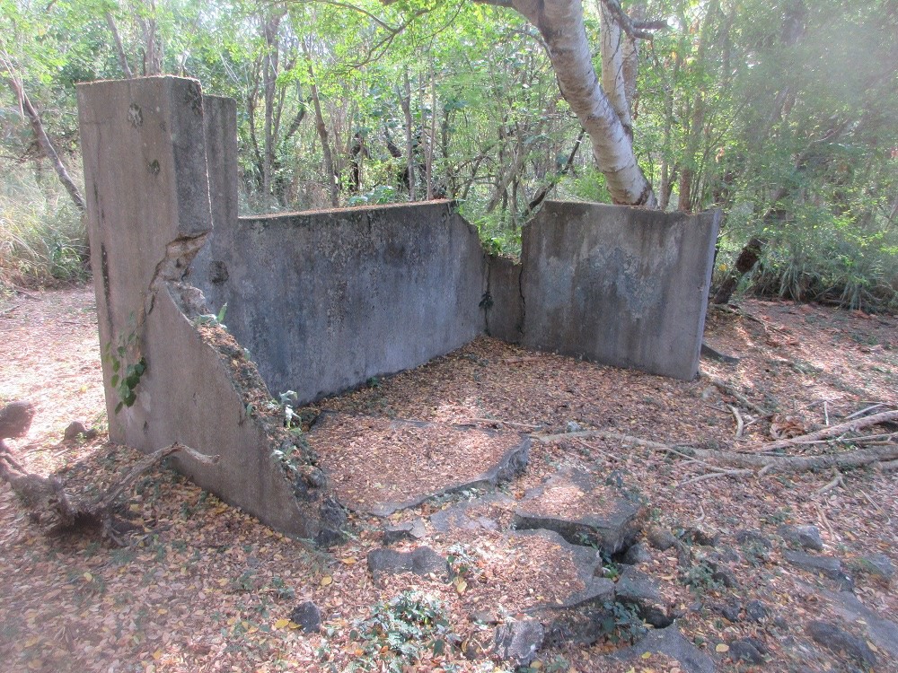
Japan in the Tropics: Okinawan House
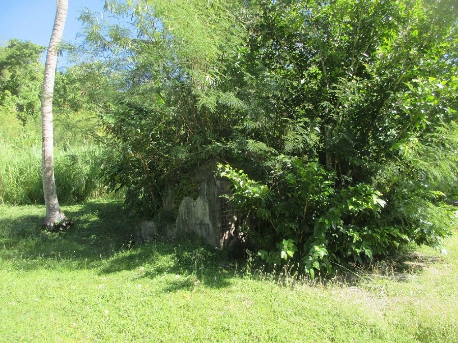
These concrete structures are the remnants of a farmestead for Japanese workers, probably Okinawan. The main structure housed two families. A concrete cistern and a bathhouse are nearby. This farmestead stood alone in the sugar fields, but a small community of about ten families lived on the southern side of the NKK shrine.
Hundreds of Japanese families immigrated to the island to work in the sugar industry. By 1935, the Japanese population was about 14,000, mostly Okinawan field laborers. Tinian Town (now San Jose Village) was the main center of population, but smaller villages and farmsteads were scattered throughout the expanses of sugarcane.
Under the laws of Japan, all of Tinian was government land. The Nan'yo Kohatsu Kaisha (NKK), South Seas Development Company, leased the land from the government. In turn, Okinawan farmers subleased land as tenant sharecroppers from the NKK.
Each family was responsible for commercial sugar cultivation of an area of six cho (15 acres)*, arranged in small rectangular fields. The farming families also grew sweet potatoes, mango, coffee, cotton, and pineapple, and they raised chickens and a few pigs and cows.
By 1944, there were nearly 18,000 civilians on Tinian, including about 2,000 Koreans. The survivors of the battle of Tinian--nearly 15,000 people--were housed on the western side of the island until they were returned to their homelands after World War II.
Normal life for the Japanese farming families of Tinian had lasted little more than a decade.
* Chō, an ancient Japanese unit of length approximately equal to 109.1 metres (357 ft 11 in) Chō, also used as a unit of area in Japan approximately 2.449 acres (0.991 ha) American Memorial
(Slide 14 of 60 )(Swipe page or use arrows to navigate)
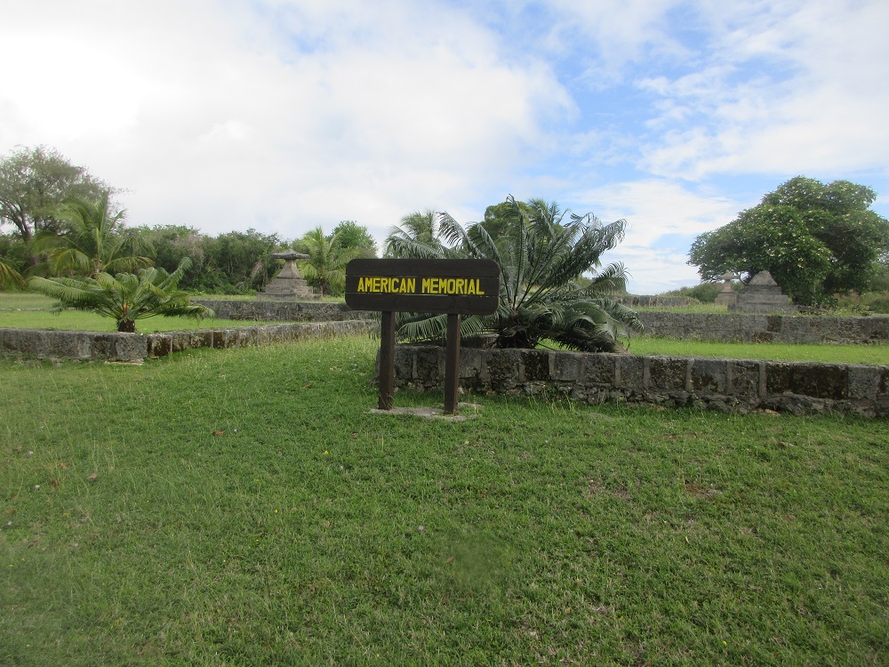
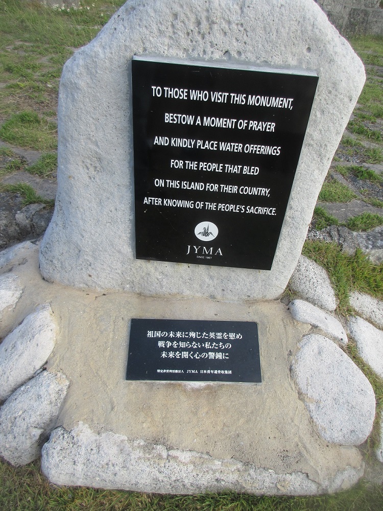
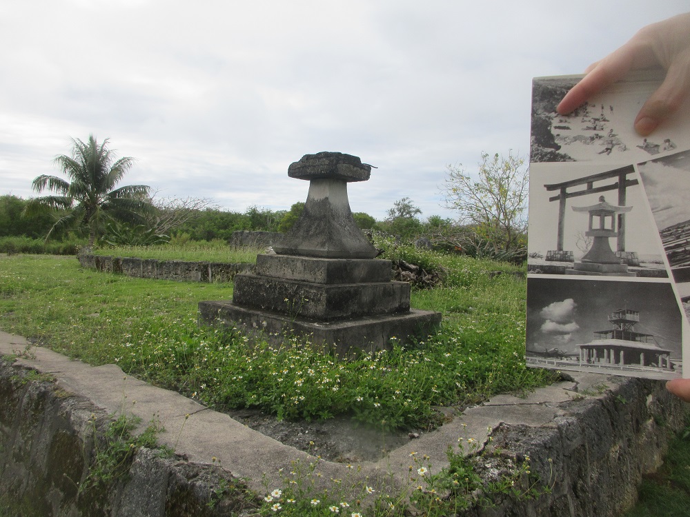
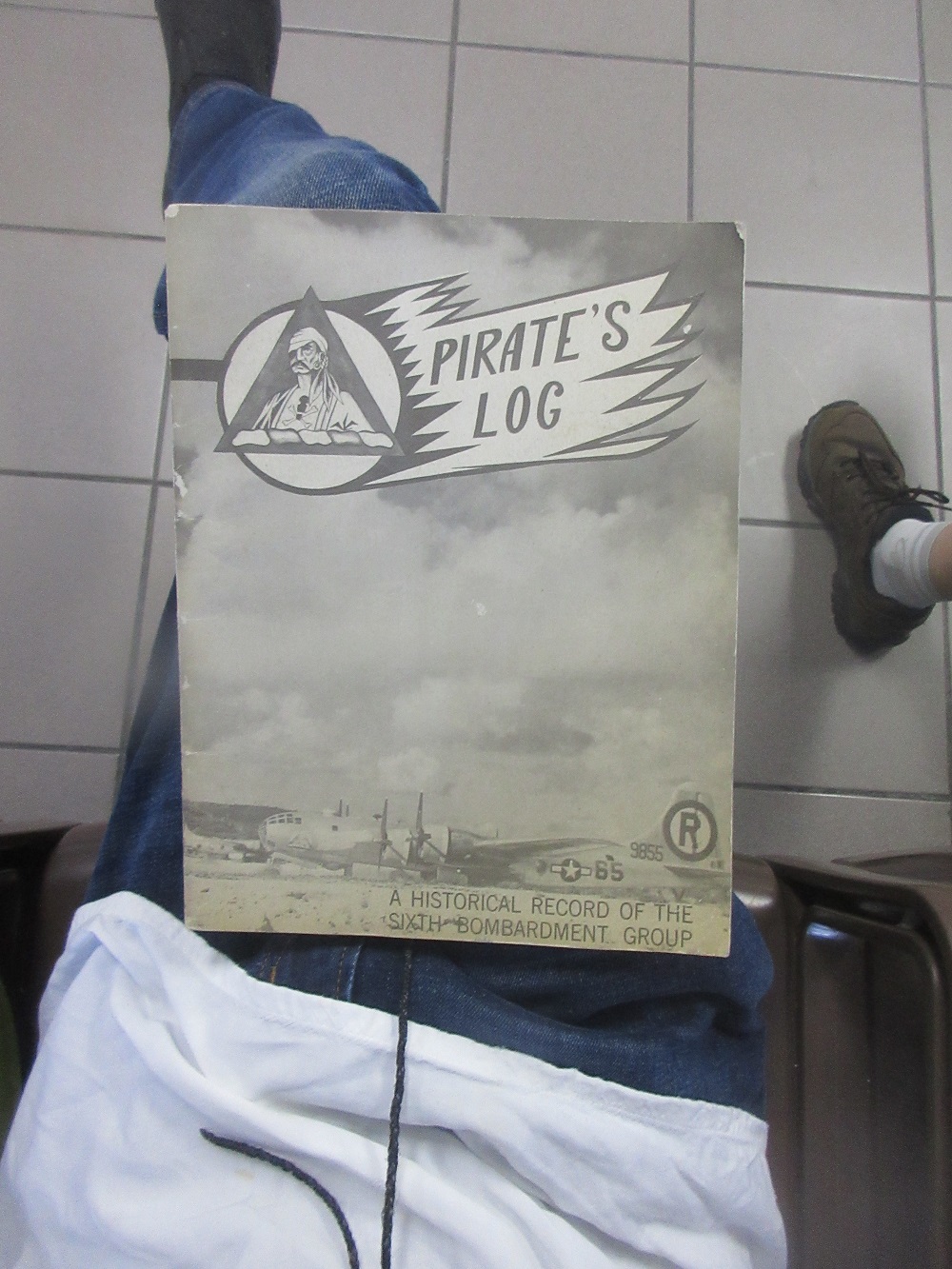
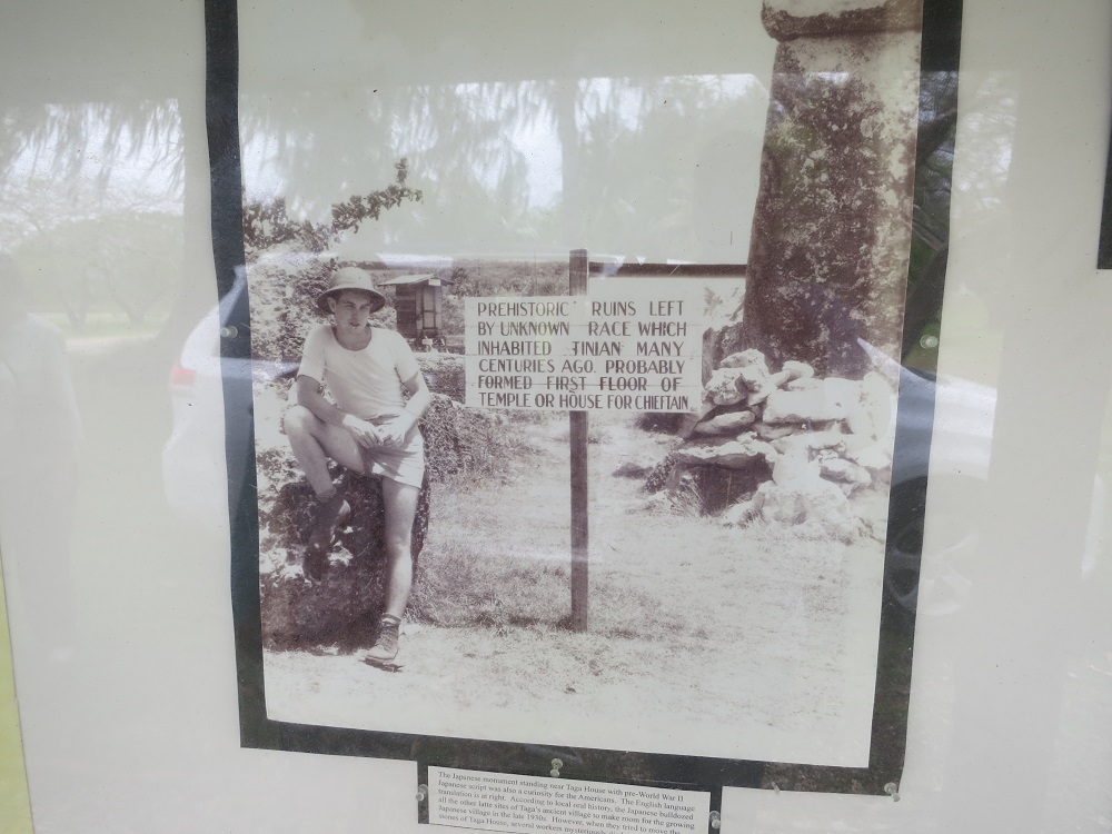
North of the Shinto Shrine and Okinawan house is a large traffic circle on Broadway. Traveling north, the road turns sharply to the east and begins its descent down to North Field plateau. The grass-covered center median of the traffic circle contains the American Memorial consisting of various Japanese-style small concrete monuments (Photo 3.8-9) that were built by Americans after World War II to honor those who were killed in the battle for Tinian.
You can see in the photo what it looked like back in the 1940s. [photo from Pirates Log: A Historical Record of the 6th Bomb Group brought along by a guest in search of his father's legacy]
Flower Gazing
(Slide 15 of 60 )(Swipe page or use arrows to navigate)
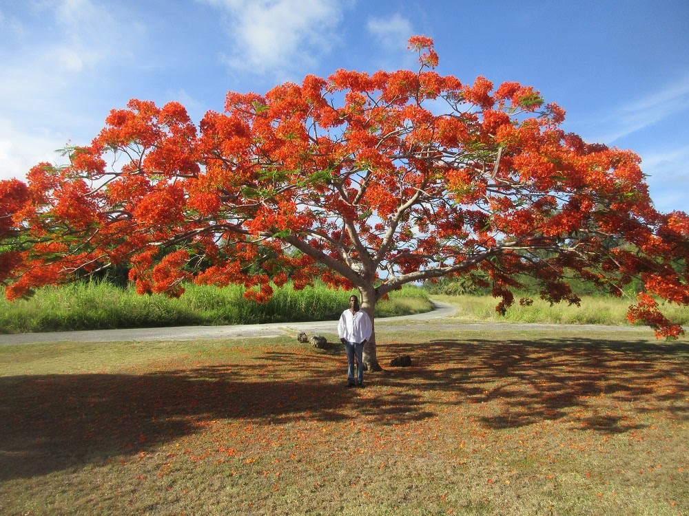
If you come at just the right time of year, this is what awaits you at the flame tree at the American Memorial as well as many other locations around these islands!
Blow Hole
(Slide 16 of 60 )(Swipe page or use arrows to navigate)
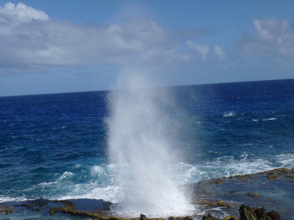
This natural wonder just off Tinian's east coast makes for great photographs and has a great view of Saipan!
Sometimes you can find sea salt that has accumulated on the rocks near the blowhole!
Let's get closer! (Got the umbrella?)
Ushi "Cross" Point
(Slide 17 of 60 )(Swipe page or use arrows to navigate)
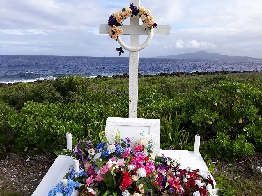
Ushi "Cross" Point is the northern-most point of Tinian. In addition to the various memorials at the point, the site and surrounding area are used by local fishermen.
War related: The major Japanese air strip at Ushi Point was one in a series of fields used in staging planes to Truk and other points in the Central and South Pacific Areas. Ushi Point Airfield extended in a single hard-surfaced runway for 4,750 feet, over 1,000 feet longer than Aslito Airfield on Saipan.
Runway Able
(Slide 18 of 60 )(Swipe page or use arrows to navigate)

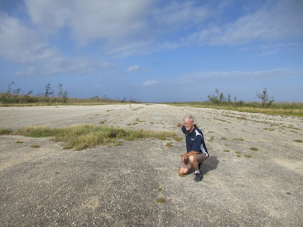
On July 24, 1944, 30,000 US Marines landed on the beaches of Tinian. Eight days later, over 8,000 of the 8,800 Japanese soldiers on the island were dead (vs. 328 Marines), and four months later the Seabees had built the busiest airfield of WWII - dubbed North Field - enabling B-29 Superfortresses to launch air attacks on the Philippines, Okinawa, and mainland Japan.
Late in the afternoon of August 5, 1945, a B-29 was maneuvered over a bomb loading pit, then after lengthy preparations, taxied to the east end of North Field's main runway, Runway Able, and at 2:45am in the early morning darkness of August 6, took off.
The B-29 was piloted by Col. Paul Tibbets of the US Army Air Force, who had named the plane after his mother, Enola Gay. The crew named the bomb they were carrying Little Boy. 6½ hours later at 8:15am Japan time, the first atomic bomb was dropped on Hiroshima.
Three days later, in the pre-dawn hours of August 9, a B-29 named Bockscar(a pun on "boxcar" after its flight commander Capt. Fred Bock), piloted by Major Charles Sweeney took off from Runway Able. Finding its primary target of Kokura obscured by clouds, Sweeney proceeded to the secondary target of Nagasaki, over which, at 11:01am, bombardier Kermit Beahan released the atomic bomb dubbed Fat Man. [Jack Wheeler]
Update: Both runways Able and Baker are used today during military activities.
2024 Update: All four runways (Able, Baker, Charlie and Dog) have been completely cleared for possible future use by the military.
Drive the entire length!
Runway Baker
(Slide 19 of 60 )(Swipe page or use arrows to navigate)
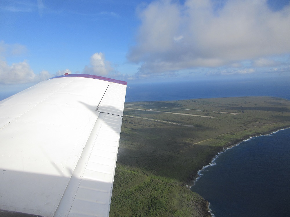
Drive Baker, Charlie & Dog!
North Field/Ushi Field
(Slide 20 of 60 )(Swipe page or use arrows to navigate)
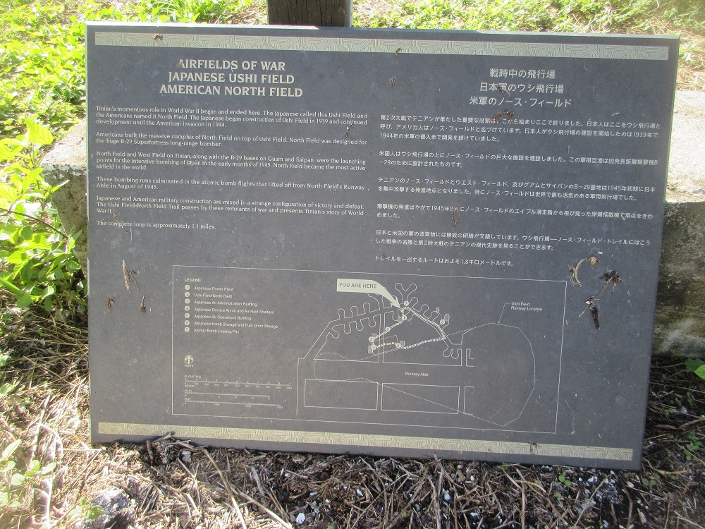
Airfields of War
Japanese Ushi Field
American North Field
Tinian's momentous role in World War II began and ended here. The Japanese called this Ushi Field and the Americans named it North Field. The Japanese began construction of Ushi Field in 1939 and continued development until the American invasion in 1944.
Americans built the massive complex of North Field on top of Ushi Field. North Field was designed for the huge B-29 Superfortress long-range bomber.
North Field and West Field on Tinian, along with the B-29 bases on Guam and Saipan, were the launching points for the intensive bombing of Japan in the early months of 1945. North Field became the most active airfield in the world.
These bombings culminated in the atomic bomb flights that lifted off from North Field's Runway Able in August of 1945.
Japanese and American military construction are mixed in a strange configuration of victory and defeat. The Ushi Field-North Field Trail passes by these remnants of war and presents Tinian's story of World War II.
The complete loop is approximately 1.1 miles.
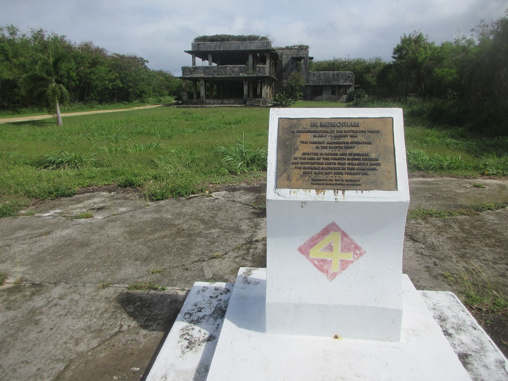
Bomb Group Memorials
(Slide 21 of 60 )(Swipe page or use arrows to navigate)
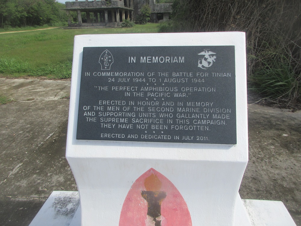
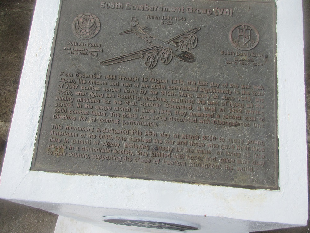
On this airfield apron are several memorials to the Bomb Groups that participated in the air raids on Japan as well as in commemoration of the actual landing beach invasion that was part of the Battle of Tinian.
24 JULY 1944 TO 1 AUGUST 1944
"THE PERFECT AMPHIBIOUS OPERATION IN THE PACIFIC WAR."
ERECTED IN HONOR AND IN MEMORY OF THE MEN OF THE SECOND MARINE DIVISION AND SUPPORTING UNITS WHO GALLANTLY MADE THE SUPREME SACRIFICE IN THIS CAMPAIGN. THEY HAVE NOT BEEN FORGOTTEN.
***
ERECTED AND DEDICATED IN JULY 2011
Visit all memorials
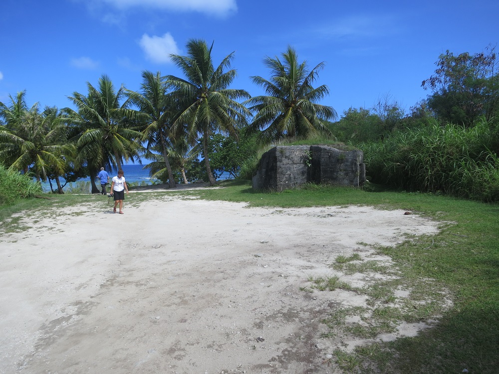
Air raid shelters
(Slide 22 of 60 )(Swipe page or use arrows to navigate)
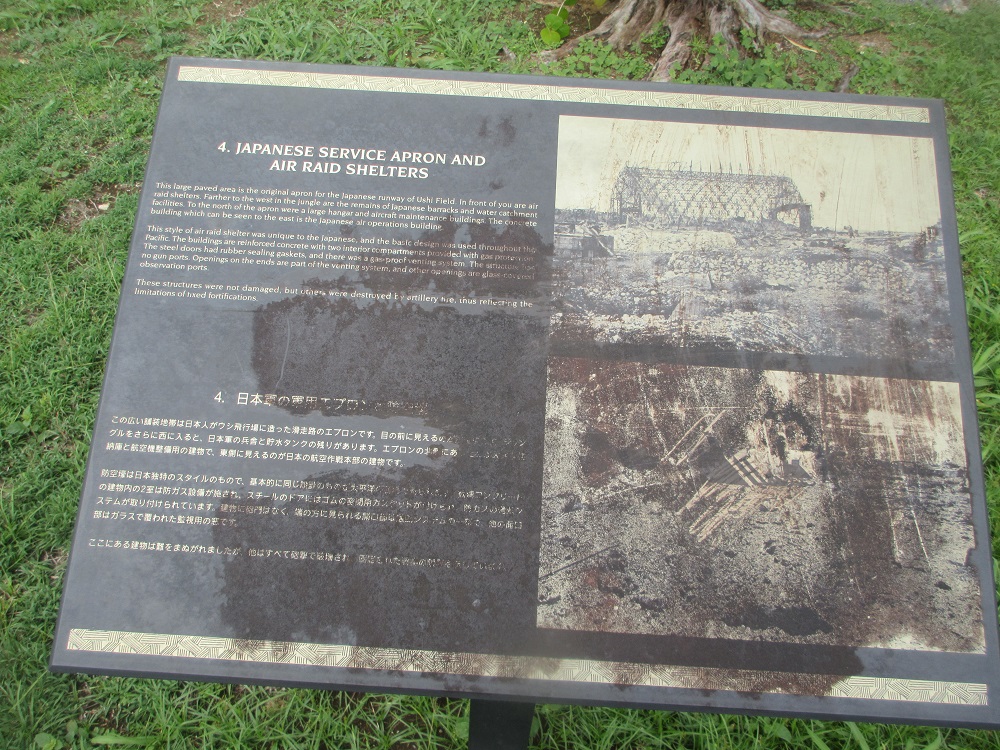
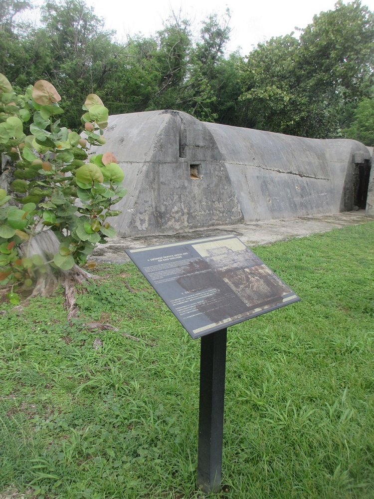
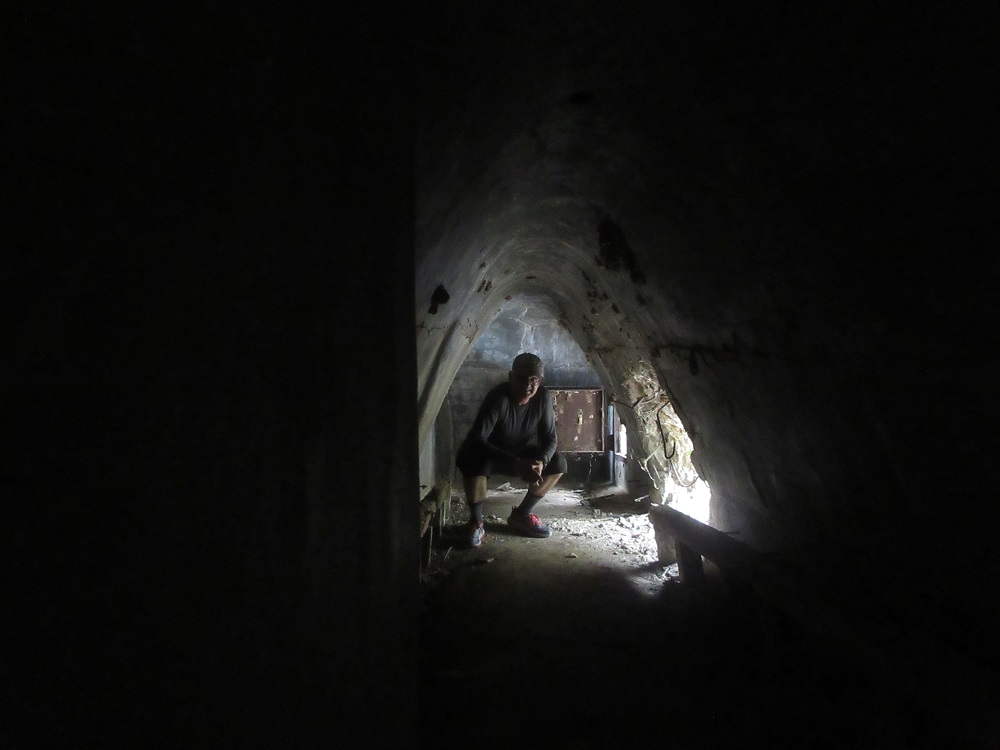
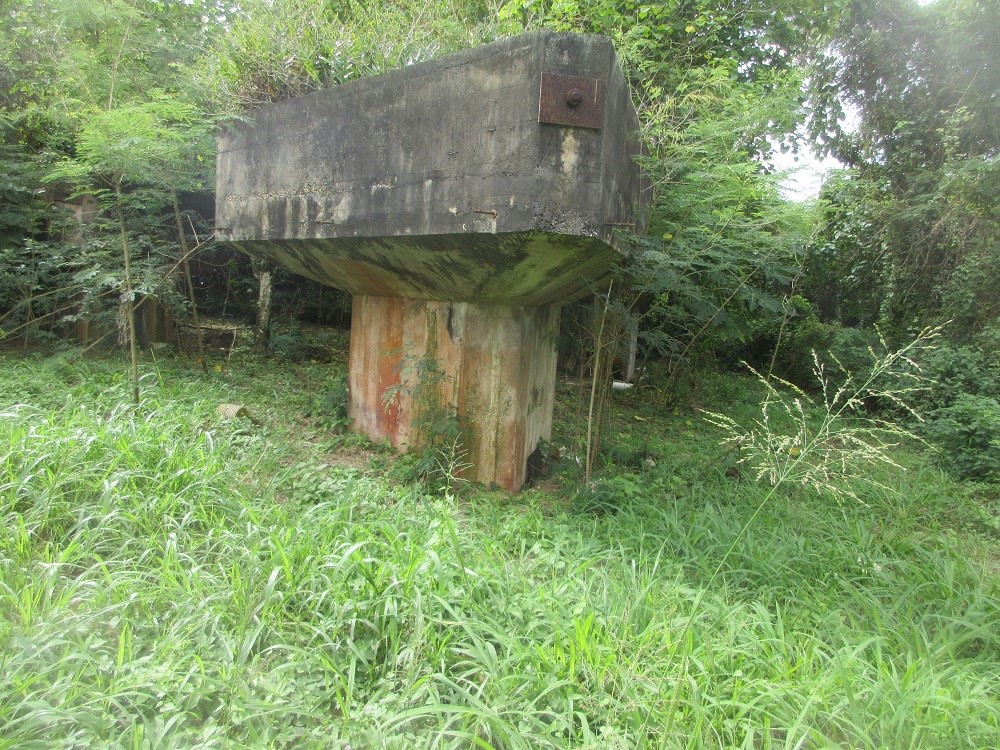
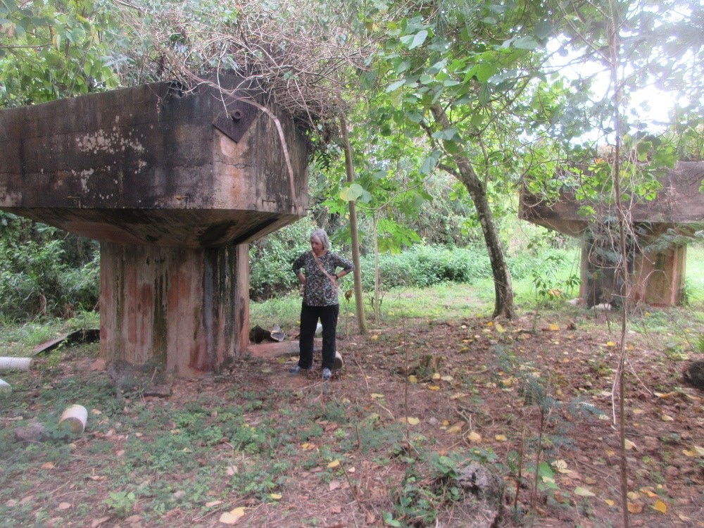
Japanese Service Apron and Air Raid Shelters
This larged paved area is the original apron for the Japanese runway of Ushi Field. In front of you are air raid shelters. Farther to the west in the jungle are the remains of Japanese barracks and water catchment facilities. To the north of the apron were a large hangar and aircraft maintenance buildings. The concrete building which can be seen to the east is the Japanese air operations building.
This style of air raid shelter was unique to the Japanese, and the basic design was used throughout the Pacific. The buildings are reinforced concrete with two interior compartments provided with gas protection. The steel doors had rubber sealing gaskets, and there was a gas-proof venting system. The structure has no gun ports. Openings on the ends are part of the venting system, and other openings are glass-covered observation ports.
These structures were not damaged, but others were destroyed by artillery fire, thus reflecting the limitations of fixed fortifications.
Venture inside air raid shelters!
Japanese Air Administration Building
(Slide 23 of 60 )(Swipe page or use arrows to navigate)
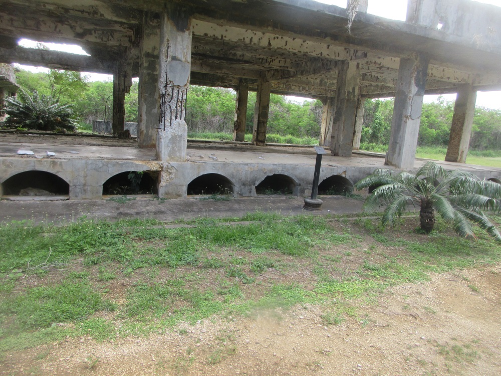
This two-story building was the World War II headquarters of the Japanese Navy's 1st Air Fleet (Base Air Force of the Marianas), commanded by Vice Admiral Kabuji Kakuta. The building and air operations were part of the Japan's Central Pacific Area Fleet. Vice Admiral Kakuta was not in the chain of command for the defense of Tinian, which was the responsibility of Colonel Kiyochi Ogata of the Japanese Army.
Admiral Kakuta's airfields in the Marianas and Iwo Jima served as staging areas for moving aircraft to southern Pacific battle areas and for attacks on American ships. By July of 1944, the airfields directed from the 1st Fleet headquarters had been captured or destroyed. What remained of Admiral Kakuta's airplanes was destroyed in the naval battle of the Philippine Sea a month before the battle of Tinian. (In Japanese history, the Battle of the Philippine Sea is known as the Battle of the Marianas.)
When Americans captured Ushi Field, the headquarters building was abandoned and Ushi Field was a "ghost-field" of abandoned airplane wrecks.
The fate of Vice Admiral Kakuta is unknown, but was probably suicide or death in battle. His last radio message to Tokyo was on July 30 as the battle of Tinian was nearing its conclusion.
The massive concrete headquarters building was damaged by American artillery, but the building was repaired and used by American military officers after the invasion.
The sign says "No Entry" but...
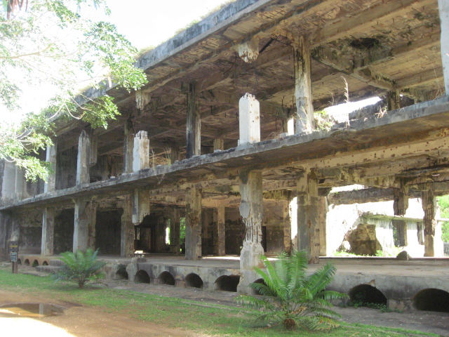
Japanese Power Plant
(Slide 24 of 60 )(Swipe page or use arrows to navigate)
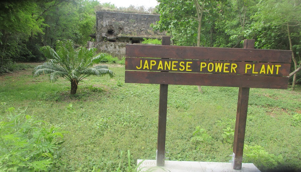
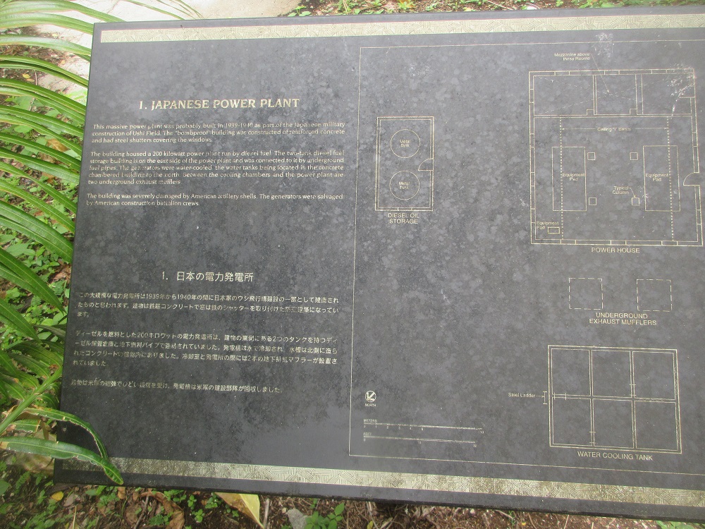
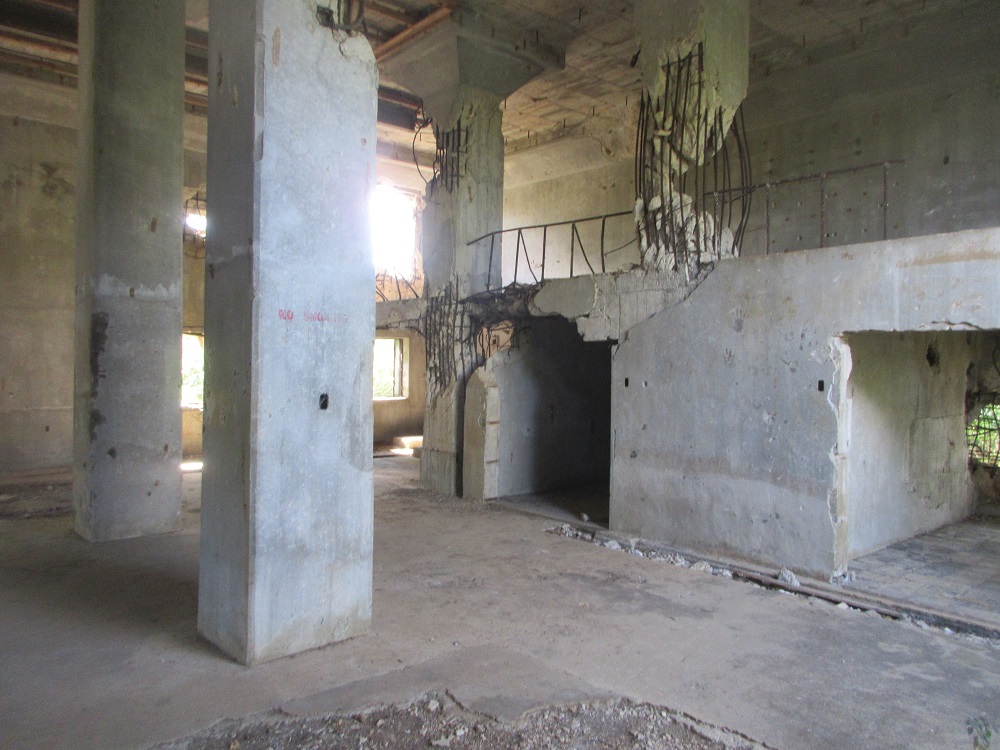
This massive power plant was probably built in 1939-1940 as part of the Japanese military construction of Ushi Field. The bombproof building was constructed of reinforced concrete and had steel shutters covering the windows.
The building houses a 200-kilowatt power plant run by diesel fuel. The two-tank diesel fuel storage building is on the north side of the power plant and was connected to it by underground fuel pipes. The generators were water-cooled, with water tanks being located in the concrete chambered buildings to the north. Between the cooling chambers and the power plant are two underground exhaust mufflers.
The building was severely damaged by American artillery shells. The generator was salvaged by American construction battalion crews.
Once you step inside the main building, you'll see the tremendous damage that direct hits from missiles can wreak on a building. Note the bent reinforcement bars and steel window frames. Amazingly, the building withstood the assault for which it was designed.
Explore inside
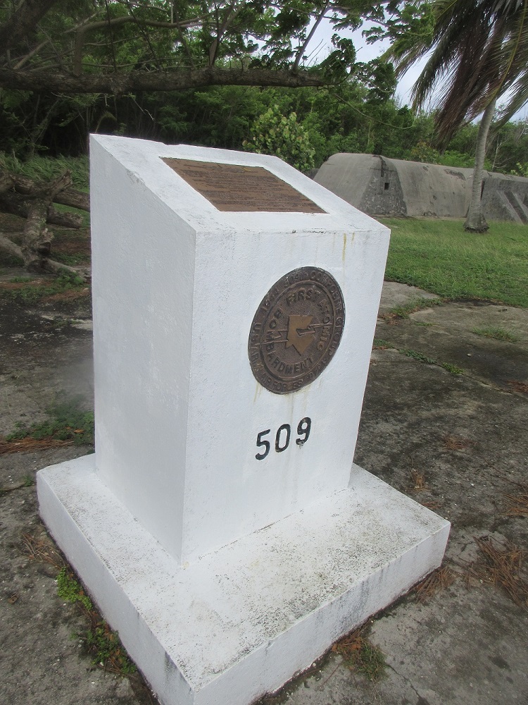
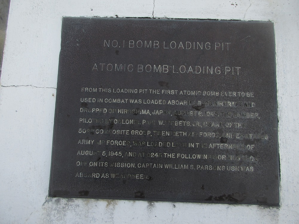
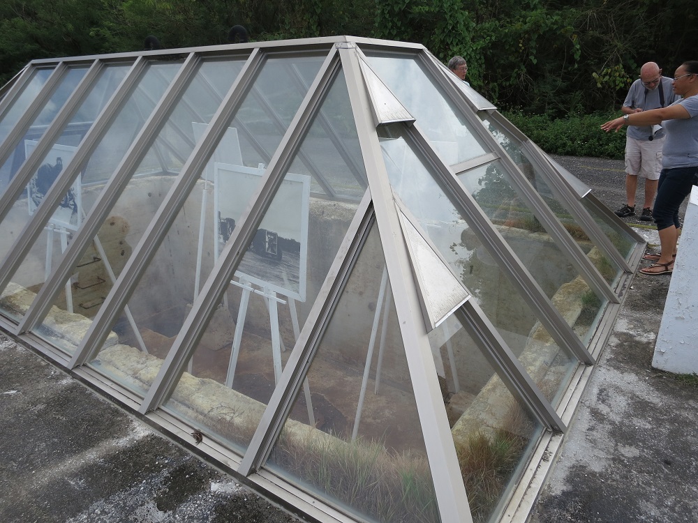
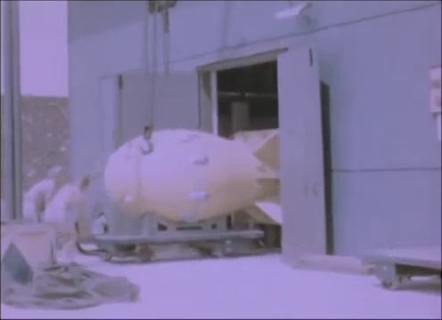
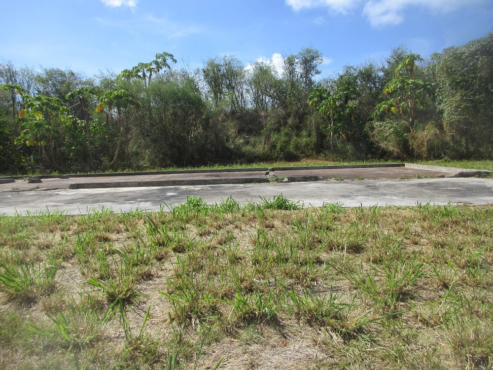
BOMB PIT 1
(Slide 25 of 60 )(Swipe page or use arrows to navigate)
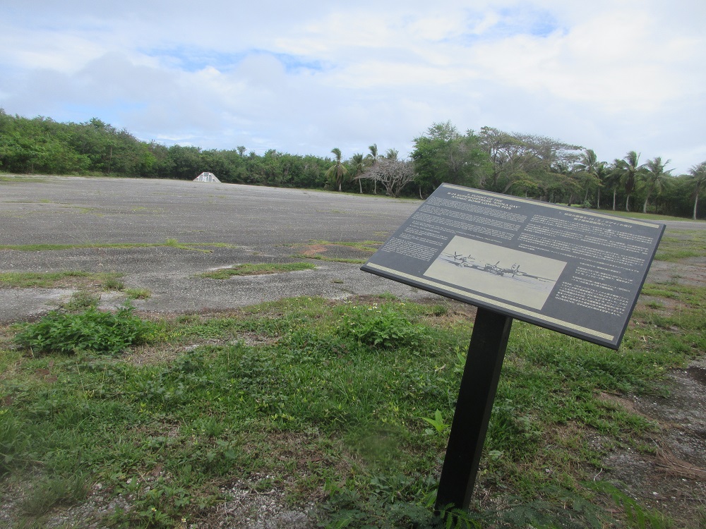
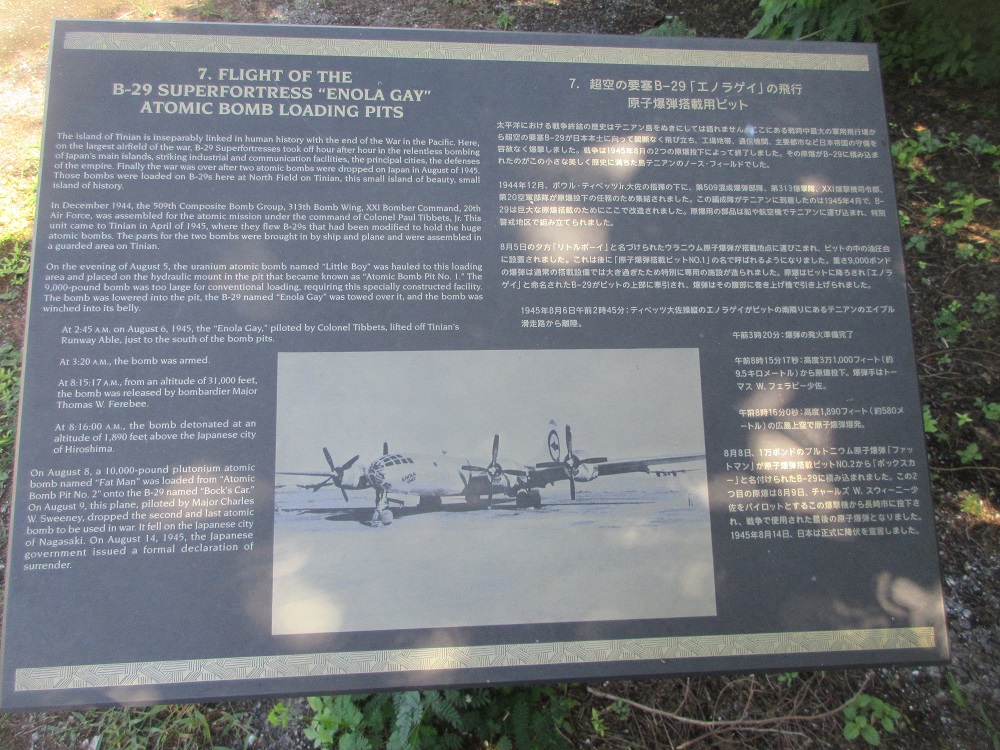
Flight of the B-29 Superfortress "Enola Gay" Atomic Bomb Loading Pits
The island of Tinian is inseparably linked in human history with the end of the War in the Pacific. Here, on the largest airfield of the war, B-29 Superfortresses took off hour after hour in the relentless bombing of Japan's main islands, striking industrial and communication facilities, the principal cities, the defenses of the empire. Finally, the war was over after two atomic bombs were dropped on Japan in August of 1945. Those bombs were loaded on B-29s here at North Field on Tinian, this small island of beauty, small island of history.
In December 1944, the 509th Composite Bomb Group, 313th Bomb Wing, XXI Bomber Command, 20th Air Force, was assembled for the atomic mission under the command of Colonel Paul Tibbets, Jr. This unit came to Tinian in April of 1945, where they flew B-29s that had been modified to hold the huge atomic bombs. The parts for the two bombs were brought in by ship and plane and were assembled in a guarded area on Tinian.
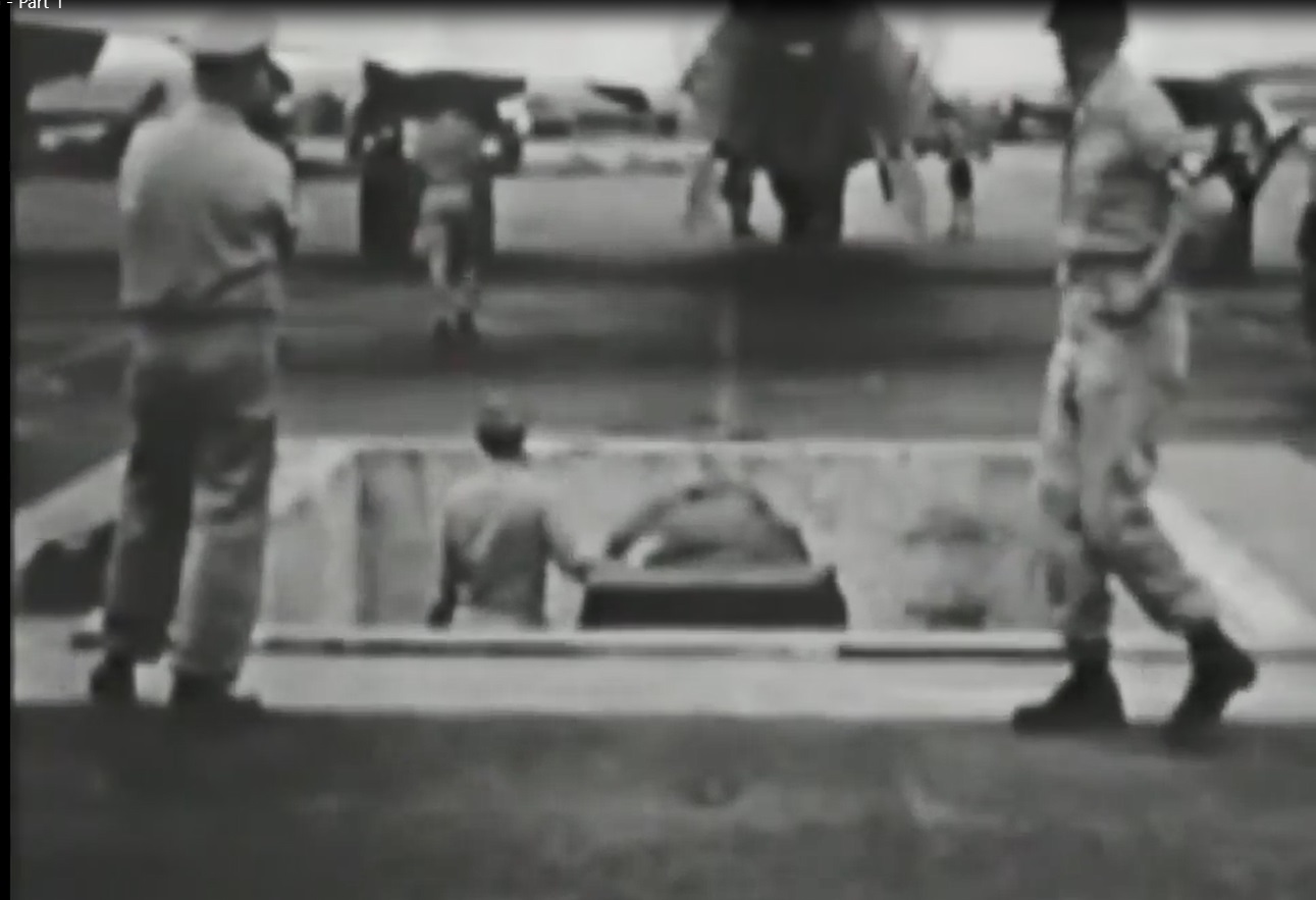
On the evening of August 5, 1945, the uranium bomb named "Little Boy" was hauled into this loading area and placed on the hydraulic mount in the pit that became known as "Atomic Bomb Pit No. 1." The 9,000-pound bomb was too large for conventional loading, requiring this specially constructed facility. The bomb was lowered into the pit, the B-29 named "Enola Gay" was towed over it, and the bomb was winched into its belly.
At 2:45 A.M. on August 6, 1945, the "Enola Gay," piloted by Colonel Tibbets, lifted off Tinian's Runway Able, just to the south of the bomb pits.
At 3:20A.M., the bomb was armed.
At 8:15:17 A.M. (Japan time), from an altitude of 31,000 feet, the bomb was released by bombardier Major Thomas W. Ferebee.
At 8:16:00 A.M., the bomb detonated at an altitude of 1,890 feet above the Japanese city of Hiroshima.
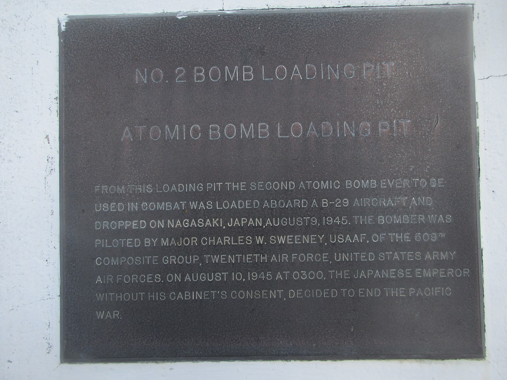
On August 8, a 10,000-pound plutonium atomic bomb named "Fat Man" was loaded from "Atomic Bomb Pit No. 2" onto the B-29 named "Bock's Car." On August 9, this plane, piloted by Major Charles W. Sweeney, dropped the second and last atomic bomb to be used in war. It fell on the Japanese city of Nagasaki. On August 14, 1945, the Japanese government issued a formal declaration of surrender.
Walk around each bomb pit
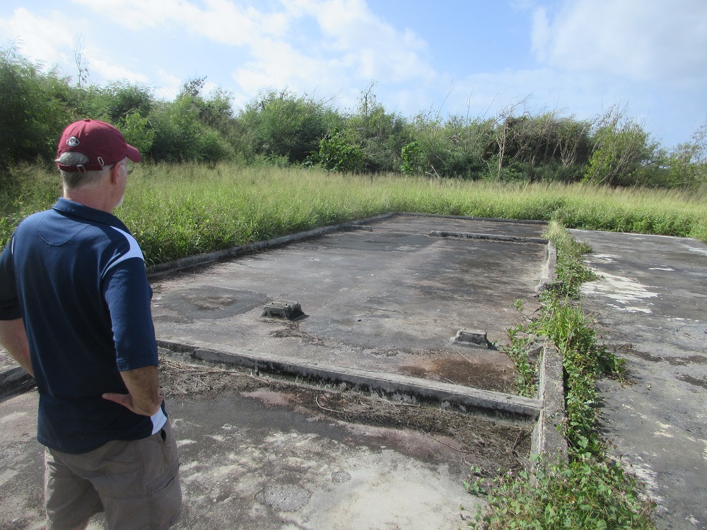
BOMB PIT 2
(Slide 26 of 60 )(Swipe page or use arrows to navigate)
Here is the second bomb pit. Here is additional information on the actual bombing:
The immediate effects were the estimated death of 70,000 people, which grew to 100,000 by year's end and later to over 200,000 after succumbing to the long-term effects of radiation. The Enola Gay is displayed at the Steven F. Udvar-Hazy Center annex of the National Air and Space Museum, located near Dulles Airport, Virginia. [northernmarianas.50webs.com]
Local lore: Despite what you may have read in history books, local historian, Don Allen Farrell, contends that both bombs (Little Boy & Fat Man) were actually loaded into their respective bombers from Bomb Pit 1 only.Walk around each pit
Atomic Bomb Assembly Area
(Slide 27 of 60 )(Swipe page or use arrows to navigate)
"Both the uranium gun bomb—Little Boy—and the plutonium implosion bomb—Fat Man—were largely pre-assembled at Los Alamos. Final assembly took place at Tinian Island in the Marianas group in the western Pacific Ocean. With an operating B-29 airfield, Tinian was used as the advance base for carrying out the delivery. The Manhattan Engineer District built special bomb assembly buildings, loading pits, and other facilities at the base. A thirty-seven-member team of scientists and specialists from Los Alamos was responsible for last-stage experiments and tests and final assembly of the bomb."
"In the early morning of July 16, the bomb was placed aboard the cruiser Indianapolis, which set sail almost immediately for Tinian via Hawaii. The Indianapolis arrived at Tinian on July 26 and disembarked the bomb that day. (Four days later, the Indianapolis was sunk by a Japanese submarine with the loss of almost 900 lives.) The final parts of the uranium bomb, including the uranium-235 target insert, were flown by two otherwise empty C-54 cargo planes from Albuquerque to Tinian, via Hamilton Field and Hawaii, arriving on the night of July 28-29. On July 30, the target insert, projectile, and initiators were assembled in the bomb." [Source: https://www.osti.gov/opennet/manhattan-project-history/]
Mount Lasso Scenic Lookout
(Slide 28 of 60 )(Swipe page or use arrows to navigate)
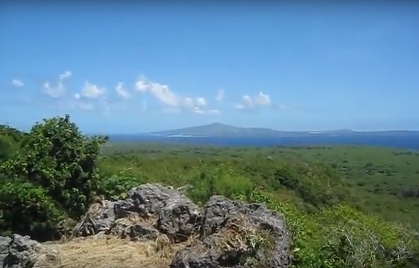
Mount Lasso, located in the central portion of the Military Lease Area, is accessed from an unimproved road extending up the west side of the mountain off of 8th Avenue. To reach the lookout, visitors pass the foundation of a former World War II Army Air Corps hospital and the remnants of a 1920s/1930s-era Japanese Shinto shrine near the lookout area.
360-degree view from Mt Lasso
Unai Lam Lam
(Slide 29 of 60 )(Swipe page or use arrows to navigate)
Unai Lam Lam is located on the northwest coast, a short distance from the atomic bomb pits. This small beach is accessed by a thickly vegetated foot trail off a narrow dirt road. The beach is approximately 52 feet (16 meters) wide and is protected by a coral reef. This location is remote and access is difficult, as the sole access is a steeply graded, rocky trail.
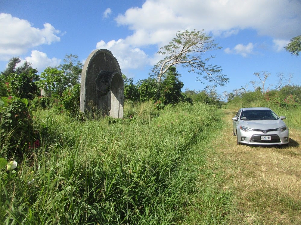
Chulu Beach (Unai Chulu) & Bunker
(Slide 30 of 60 )(Swipe page or use arrows to navigate)
Unai Chulu is located south of Unai Babui. Unai Chulu was designated “White Beach Two” by the Allies during the World War II invasion and is also part of the North Field National Historic Landmark. Unai Chulu is the most accessible beach in the Military Lease Area. Access to the beach is well marked along an improved road. This beach is approximately 479 feet (146 meters) long, with a World War II Japanese bunker located at the north end adjacent to the parking area. Like Unai Lam Lam and Unai Babui, Unai Chulu is on the leeward (western) side of the island and is less windswept with thicker and taller vegetation than east coast beaches. The beach consists of white sand and a rocky shoreline.
Walk the 60-yard beach
Amphibious Landing Craft
(Slide 31 of 60 )(Swipe page or use arrows to navigate)
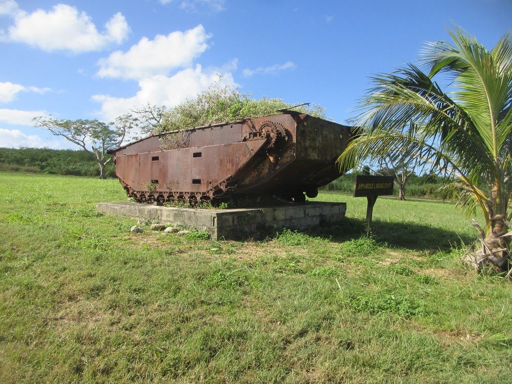
In the middle of the 8th Avenue traffic circle sits a unique site. This LCV (Landing Craft Vehicle) participated in the historic landing of the Battle of Tinian.
Walk around, climb on top
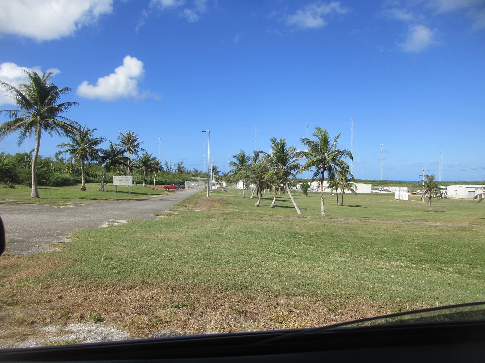
The 509th Composite Group Camp
(Slide 32 of 60 )(Swipe page or use arrows to navigate)
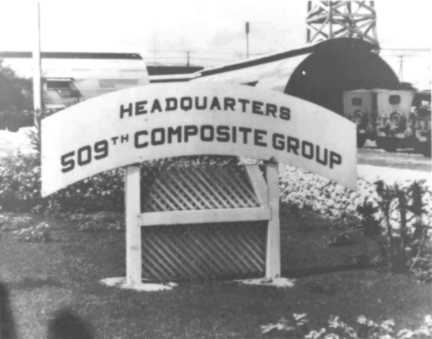
The 509th Composite Group was the U.S. Army Air Corps unit responsible for the delivery of the atomic bombs that were dropped on the Japanese cities of Hiroshima and Nagasaki at the end of World War II. The group’s camp area was southeast of the 8th Avenue traffic circle, just south of the North Field National Historic Landmark. The camp location is marked by a sign, and the ruins of building foundations can be found along trails that have been cleared in the thick vegetation
Voice of America
(Slide 33 of 60 )(Swipe page or use arrows to navigate)
Voice of America (VOA) is a U.S. multimedia agency which serves as the United States non-government institution for non-military, external broadcasting. It is the largest U.S. international broadcaster. VOA produces digital, TV, and radio content in more than 40 languages which it distributes to affiliate stations around the globe. It is primarily viewed by foreign audiences, so VOA programming has an influence on public opinion abroad regarding the United States and its people.
Categories: Contemporary CNMI life
B-29 Homing Tower
(Slide 34 of 60 )(Swipe page or use arrows to navigate)
The B-29 missions were dangerous, and it took a coordinated effort to ensure a safe return to Tinian. A key component of this was a homing beacon constructed on Mt. Lasso. The tripod pedestals of this beacon remain standing to this day. [Source: https://storymaps.arcgis.com]
Camp Chulu
(Slide 35 of 60 )(Swipe page or use arrows to navigate)
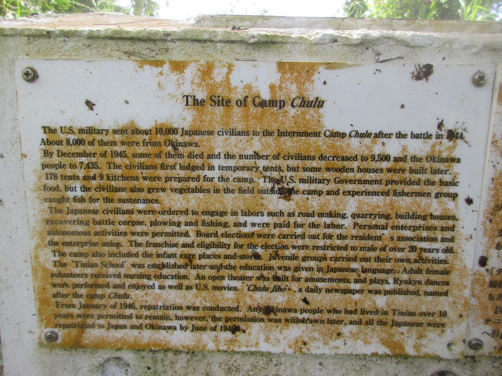
The Site of Camp Chulu
The U.S. military sent about 10,000 Japanese civilians to the Internment Camp Chulu after the battle in 1944. About 8,000 of them were from Okinawa.
By December of 1945, some of them died and the number of civilians decreased to 9,500 and the Okinawa people to 7,435. The civilians first lodged in temporary tents, but some wooden houses were built later.
178 tents and 9 kitchens were prepared for the camp. The U.S. military government provided the basic food, but the civilians also grew vegetables in the field outside the camp and experienced fishermen groups caught fish for sustenance.
The Japanese civilians were ordered to engage in labors such as road making, quarrying, building houses, recovering battle corpses, plowing and fishing, and were paid for the labor. Personal enterprises and autonomous activities were permitted. Board elections were carried out for the residents association and the enterprise union. The franchise and eligibility for the election were restricted to males of over 20 years old.
The camp also included infant care places and stores. Juvenile groups carried out their own activities.
The Tinian School was established later and the education was given in Japanese language. Adult female volunteers received nursing education. An open theater was built for amusements and plays. Ryukyu [Traditional Okinawan] dances were performed and enjoyed as well as U.S. movies. 'Chulu Jiho,' a daily newspaper was published, named after the camp Chulu.
From January of 1946, repatriation was conducted. Any Okinawa people who had lived in Tinian over 10 years were permitted to remain. However, the permission was withdrawn later, and all the Japanese were repatriated to Japan and Okinawa by June of 1946.
Drive to Camp Chulu
Seabees Monument
(Slide 36 of 60 )(Swipe page or use arrows to navigate)
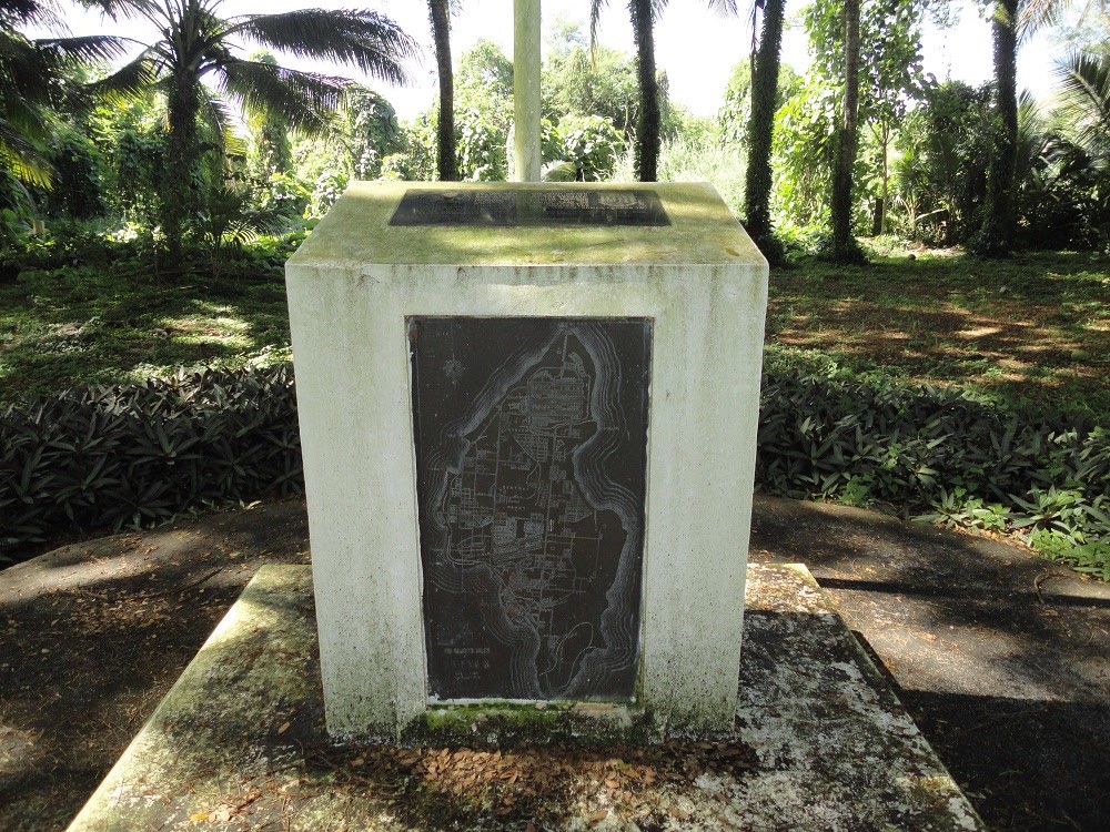
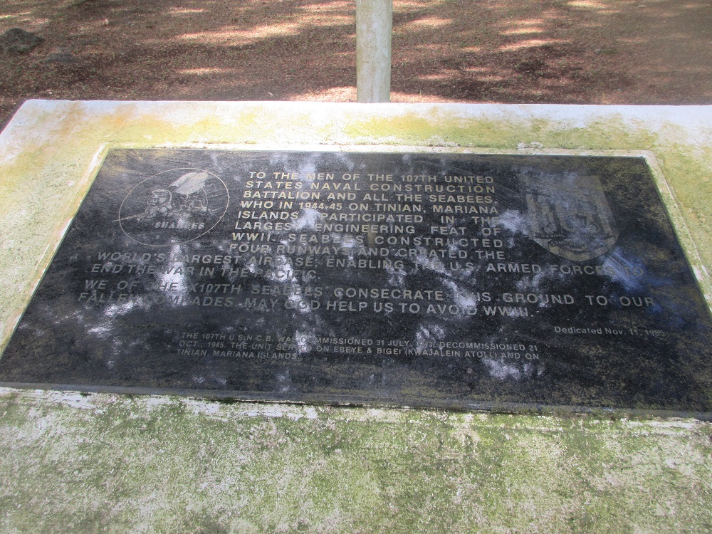
Inscription on Monument: "To the men of the 107th United States Naval Construction Battalion and all the Seabees who in 1944-45 on Tinian, Mariana Islands, participated in the largest engineering feat of WWII. Seabees constructed four runways and created the world's largest airbase; enabling the U.S. armed forces to end the war in the Pacific."
"We of the 107th Seabees consecrate this ground to our fallen comrades. May God help us to avoid WWIII." (Dedicated Nov 11, 1985)
The 107th U.S.N.C.B. was commissioned 31 July 1943, decommissioned 21 Oct. 1945. The unit served on Ebeye & Bigei (Kwajalein Atoll) and on Tinian, Mariana Islands.
The Manhattan Connection!
155mm (6-inch) Japanese Cannon!
(Slide 37 of 60 )(Swipe page or use arrows to navigate)
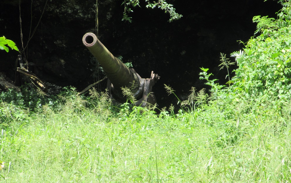
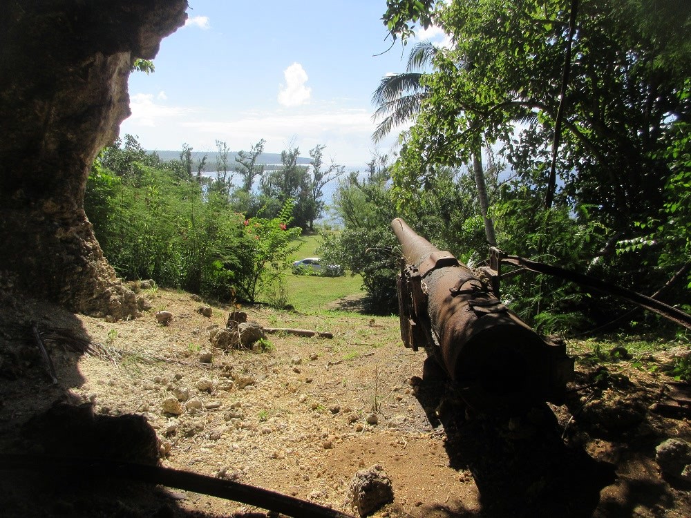
This one may be a little tricky to find! Hope you have a four-wheel-drive vehicle and a knowledgeable guide!
Find it then explore the cave
Santa Lourdes Shrine
(Slide 38 of 60 )(Swipe page or use arrows to navigate)
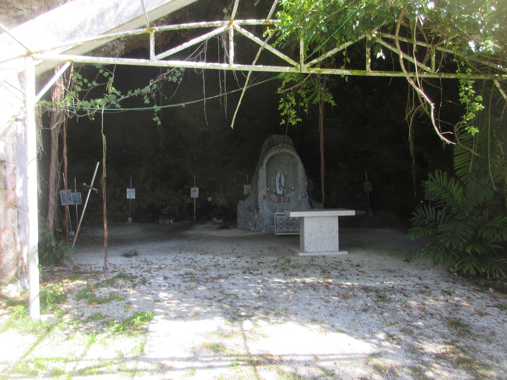
Discover the Santa Lourdes Shrine, Korean Memorial and Japanese Crematory on this site next to the Northern Mariana College.
Explore
Korean Memorial
(Slide 39 of 60 )(Swipe page or use arrows to navigate)
Discover the Santa Lourdes Shrine, Korean Memorial and Japanese Crematory on this site next to the Northern Mariana College.
Japanese Crematory
(Slide 40 of 60 )(Swipe page or use arrows to navigate)
Discover the Santa Lourdes Shrine, Korean Memorial and Japanese Crematory on this site next to the Northern Mariana College.
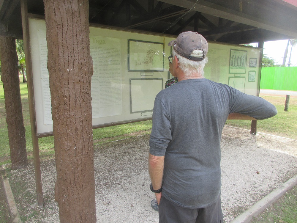
Taga Village & Japanese Era Town
(Slide 41 of 60 )(Swipe page or use arrows to navigate)
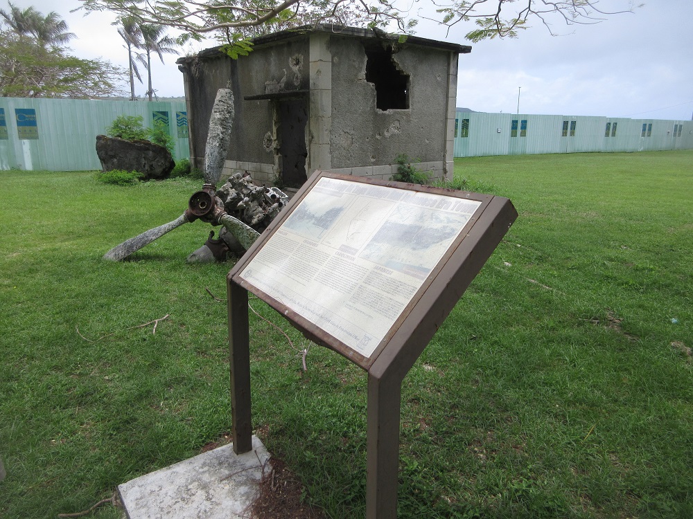
"This ponding basin was constructed in 2009 by CNMI Department of Public Works to trap sediment and pollutants in runoff from highways 201 and 202. Construction of the basin resulted in discovery of significant archaeological resources from the indigenous Latte Period and from Japanese buildings dating to the early 20th century. A professional archaeology company documented features and recovered human remains that could not be preserved in place. In an effort to minimize effects of the construction on the archaeological records, the basin was reconfigured to preserve and protect other burials and features that lie within the fenced area."
"The House of Taga, located close by, was the central building in a village that contained at least 18 latte houses. Sometime after 1924, when Hans Hornbostel produced his sketch of the village, all of the above-ground elements were removed from the site. This area became part of a Japanese tour; a restaurant stood in this area. After the 1944 invasion of the Marianas by American military forces, the surrounding area was further disturbed by enlargement of the existing Japanese harbor to provide berthing for American ships delivering cargo to support the huge B-29 bases that were being constructed on the island. Any remaining latte, with the exception of the House of Taga, were probably removed at that time."
Visit or call (433-0220), the Tinian Historical Preservation Office, for additional information.
House of Taga
(Slide 42 of 60 )(Swipe page or use arrows to navigate)
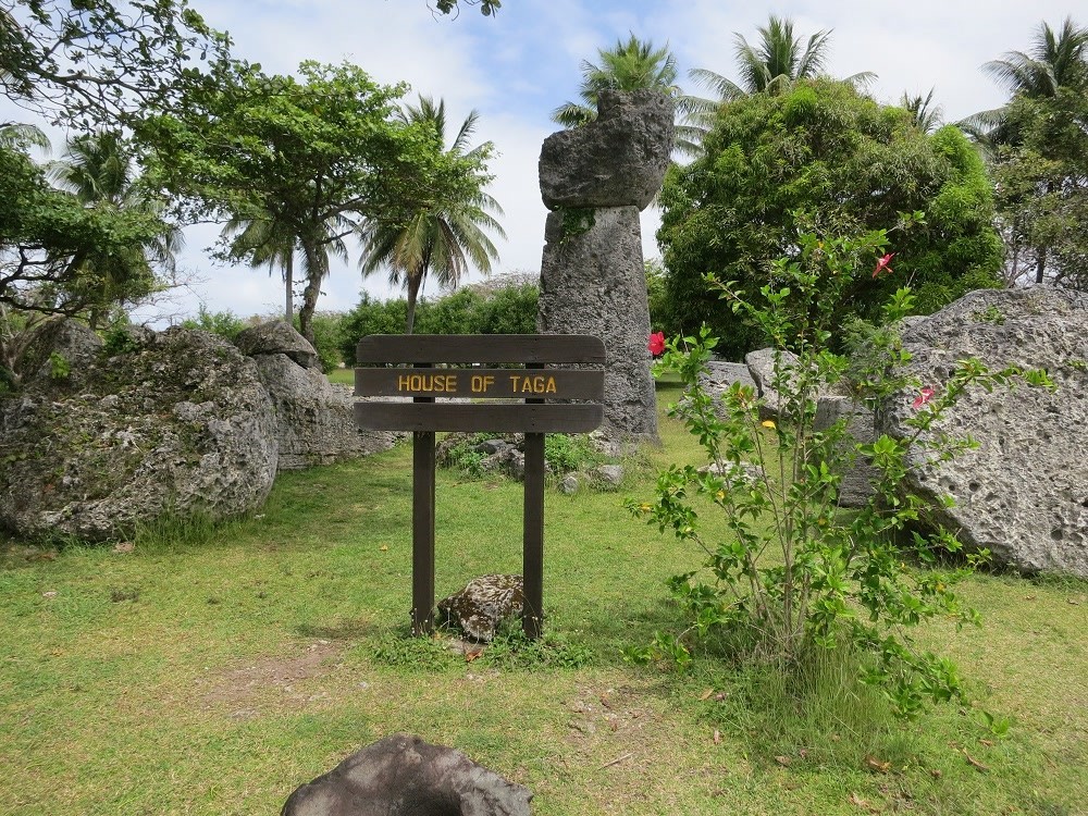
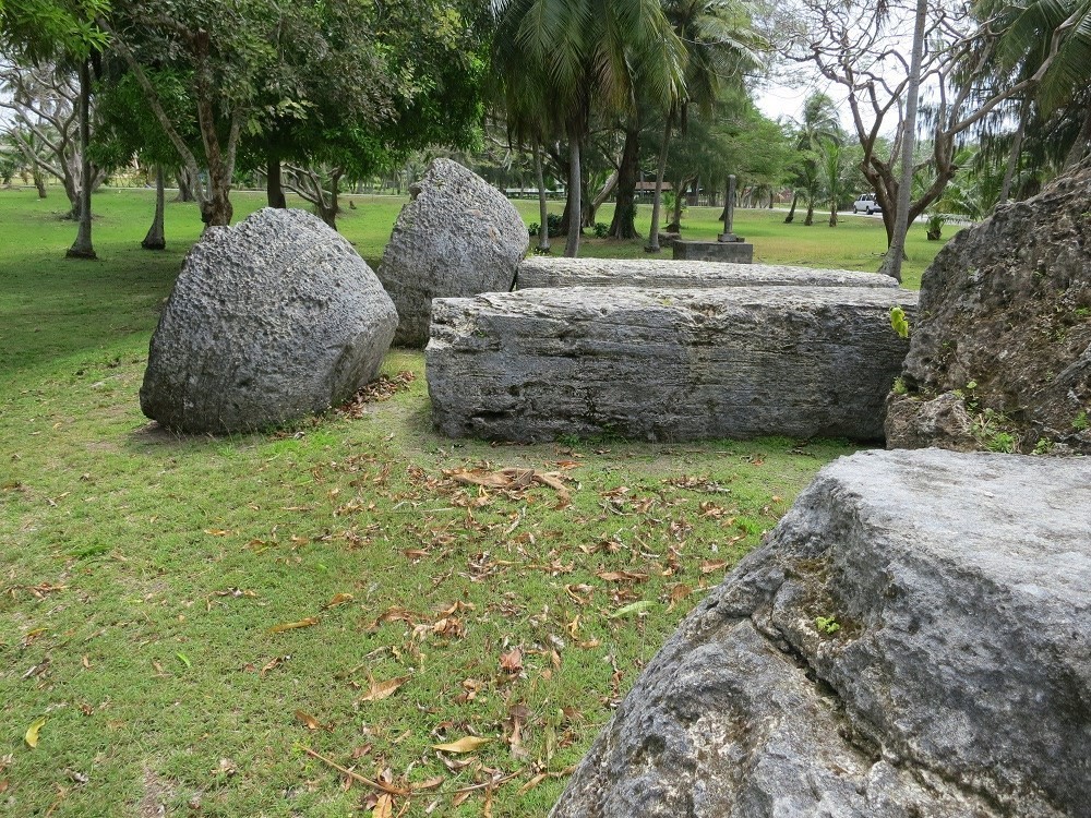
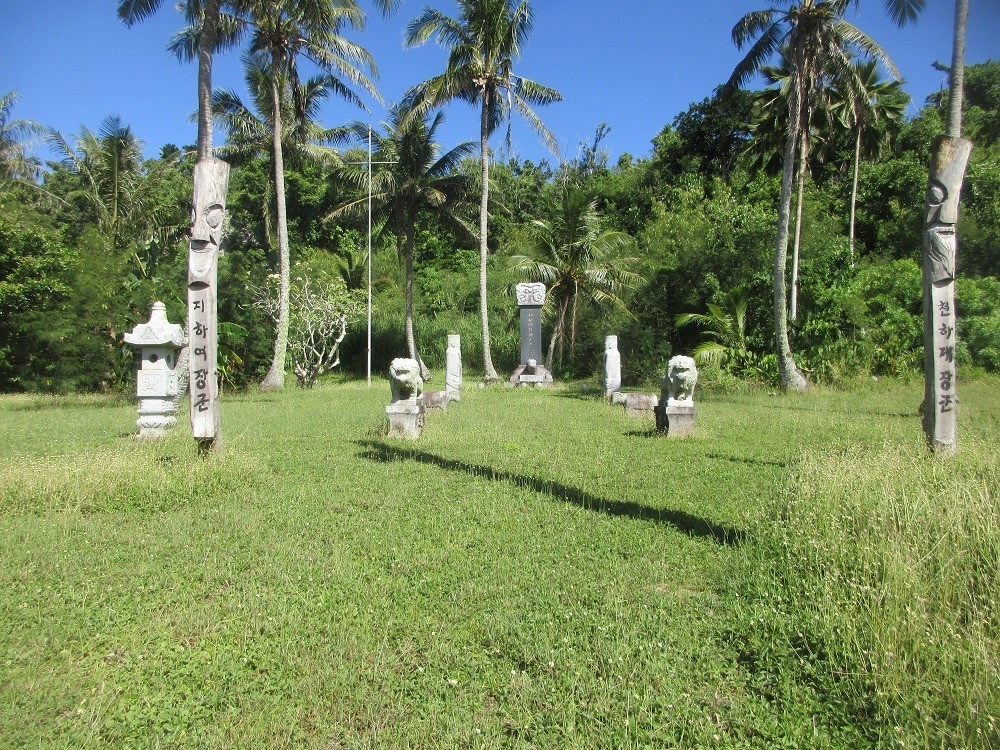
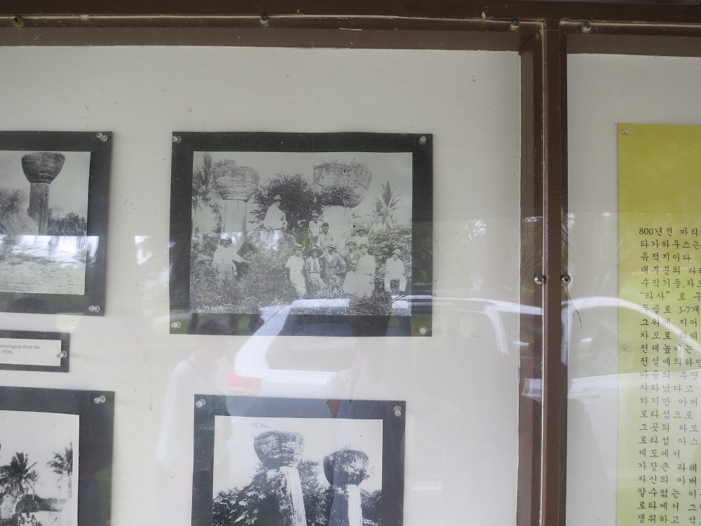
The remnants of a house belonging to the ancient Chamorro chief Taga, are in the village of San Jose. This site contains the tallest set of latte stones used by the ancient Chamorros throughout the CNMI. Latte stones are pillars capped by a hemispherical stone capital with the flat side facing up that were used as building supports by the ancient Chamorro people. The stones are quarried limestone, each approximately 19 feet (6 meters) in length. Of the 12 large latte structures, only one remains standing (Photo 3.8-13). The Ruins of the House of Taga are listed on the National Register of Historic Places.
Explore the site
House of Taga Interpretive Center
(Slide 43 of 60 )(Swipe page or use arrows to navigate)
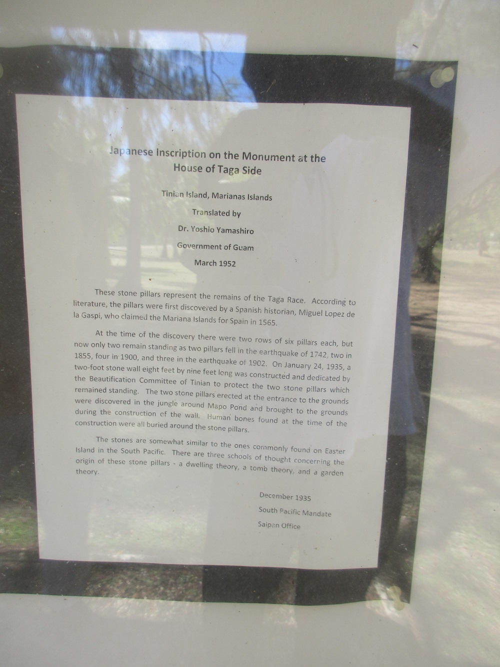
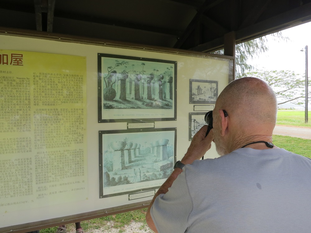
Japanese Inscription on the Monument at the House of Taga Side
Tinian Island, Mariana IslandsTranslated by Dr. Yoshio Yamashiro
Government of Guam
March 1952
These stone pillars represent the remains of the Taga Race. According to literature, the pillars were first discovered by a Spanish historian, Miguel Lopez de la Gaspi, who claimed the Mariana Islands for Spain in 1565.
At the time of the discovery, there were two rows of six pillars each, but now only two remain standing as two pillars fell in the earthquake of 1742, two in 1855, four in 1900, and three in the earthquake of 1902. On January 24, 1935, a two-foot stone wall eight feet by nine fee long was constructed and dedicated by the Beautification Committee of Tinian to protect the two stone pillars which remained standing. The two stone pillars erected at the entrance to the grounds were discovered in the jungle around Mapo Pond and brought to the grounds during the construction of the wall. Human bones found at the time of the construction were all buried around the stone pillars.
The stones are somewhat similar to the ones commonly found on Easter Island in the South Pacific. There are three schools of thought concerning the origin of these stone pillars--a dwelling theory, a tomb theory and a garden theory.
December 1935
South Pacific Mandate
Saipan Office
Text of Interpretive Center
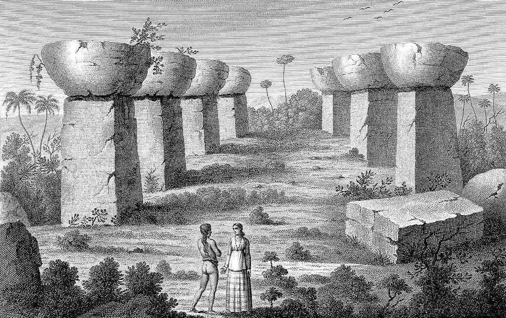
Found nowhere else in the world, latte stones first appeared in the Mariana Islands about 800 years ago, a period known as the latte era of Chamorro culture. Each stone is comprised of a vertical pillar (haligi) and a hemispherical capstone (tasa). Organized in two rows of 3 to 7 stones, the latte stones served as foundation posts for wood and thatch houses that were built on top of them. Representing the apex of Chamorro latte architecture, the massive stones of Taga House are 15 feet in overall length.
According to legend, Taga was born to the maga'lahi [Male leader. A maga'låhi is the first born, high ranking (matua) male head of a Chamorro clan, a role inherited through his maternal lineage] of Ritidian Village, Guam. According to Chamorro legend, Taga was a giant. Dissatisfied with his father's rule, the boy challenged his father to a fight. Losing, Taga moved to Rota, where he challenged the leading maga'lahi to a series of contests. Winning, he married a local Chamorrita and had a daughter. At As Nieves, Rota, he began excavating what would have been the largest latte stones in the Marianas. Perhpas he was trying to impress his father. For an unknown reason, Taga moved from Rota to Tinian without lifting the stones out of the ground. As he had on Rota, the giant Taga gained power on Tinian and had a son. He then oversaw the construction of his home, The House of Taga, on Sanhalom Bay. The house consisted of 12 latte stones with a wooden house built on top of the stones.
According to legend, when the son of Taga turned five years old, Taga gave him a giant ayuyu (coconut crab) as a gift. Unfortunately, while the boy was walking the crab, it cut the twine leash and ran under a young coconut tree. The boy ran back to Taga House and asked his father to push over the coconut tree so he could get the crab. Taga refused, explaining that the coconuts were just beginning to bear fruit. The boy became furious. He ran back to the tree and shook it furiously, finally pushing over the tree himself. While the boy was pulling the crab from the hole he had just created, he noticed water. It was fresh water. He gave the well to his half-sister for her to bathe in.
When Taga saw his young son perform this great feat of strength, he recognized that the boy might become bigger and stronger than even himself. He remembered fighting his own father. That night, Taga crept into the boy's room and smothered him to death.
Taga's daughter saw this. She became so frightened, she ran away to the deep forest and hid. By the time she returned to her mother, the girl was so weak that she died. Taga buried the girl in a cavity dug in one of the tasa of Taga House. This grieved the mother so much, she too died. This left Taga, the biggest and strongest of all Chamorro maga'lahi, shemed.
The first historical record of Taga House resulted from the wreck of the Nuestra Señora de la Concepción. This Manila Galleon was bound for Acapulco with a load of precious spices, porcelain, worked gold and silver jewelry and other commodities. Disabled by a typhoon, Concepción foundered at Aguigan Point, Saipan on September 20, 1638. The stern portion of the ship broke off and drifted away. As it passed Chulu Village on the northwestern shore of Tinian, Taga saw survivors on the wreckage and paddled a canoe through rough water to save them. He brought the men to Taga House, where they recuperated. While recovering from his strenuous ordeal, Taga had a vision of a woman holding a baby. The Spaniards interpreted this to be a vision of the Virgin Mary and Baby Jesus. One of the survivors, Marcos Fernandez de Corcuera, baptized him as Sebastian Hurtado de la Corcuera in honor of his father, the governor-general of the Philippines. Taga, therefore, became the first Chamorro Christian. A small circular stone receptacle near the base of the last standing latte stone marks where they first Spanish cross was erected in the Marianas.
Taga sent the Spaniards to Guam with some of his men, with a message to Quipuha, maga'lahi of Hagåtña. to help them return to the Philippines. The Spaniards arrived safely back in Manila, where they reported the loss of Concepción and their experience with Taga, including his request to send more missionaires to the Marianas.
According to the Spanish records, in 1695, the Spanish conquistador, Don Jose Quiroga left Guam to subdue Tinian--the last bastion of the Chamorro resistance. According to the legend, Taga took all the Chamorros to Aguiguan. They piled rocks along the top of the plateau to throw down on the Spaniards. Unfortunately for the the Tinian Chamorros, a group of converted Guam chamorri, lead by Antonio Inoc, sided with Spaniards. Despite having boulders thrown down on them, Inoc's men scaled the cliffs. Shortly, Spanish guns overpowered Chamorro spears and sling-stones. All the Tinian and Aguiguan Chamorros were killed or captured except Taga. Some jumped to their death rather than be subdued. The surviving Tinian and Aguiguan Chamorros were taken to Guam for resettlement; except Taga, who hid in one of Aguiguan's many caves.
The first recorded illustration of Taga House occurred in 1742 when British Commodore George Anson sought refuge for his ship, the 64-gun frigate Centurion, on Tinian. Having been at sea for two years searching for a galleon to capture, Centurion needed repairs and Anson's men, many near death, needed to recuperate. During the two months Anson spent on Tinian, one of his crewmen, Piercy
Bret, drew several sketches of Taga House. All twelve stones remained standing at that time. Anson said the House of Taga "consisted of two rows of square, pyramidal pillars, each pillar being about 6 feet from the next, and the distance between the rows being about twelve feet; the pillars themselves are about five feet square at the base, and about thirteen feet hight; and on top of each of them there is a semi-globe, with the flat part upwards..."
The French explorer, Louis de Freycinet, visited the Mariana/s in 1819 during his voyage around the world. His draftsman, Jacques Arago, visited Tinian and did several drawings of Taga House. Freycinet reported that seven stones remained standing.
Governor of the Marianas, Luis de Ibañez y Gracoa visited Tinian on 19 August 1872. Interested in the legend of Taga, he "had a ladder brought and climbed on the top of the pillar...and found a cavity full of earth. After it had been cleaned out...Ibañez y Garcia found a piece of human lower jaw and two smal bones, evidently finger phalanges [possibly those of Taga's daughter]. That tasa has fallen down and the cavity is now easily seen."
The first photograph of Taga House was taken in 1888 when the French botanist, Alfred Antoine March, visited Tinian. At that time, only seven stones remained standing. Georg Fritz, who became the first German District Officer of the Marianas in 1900, reported five stones standing.
By the time the Japanese archaeologists Ichiro Yawata and Kotondo Hasabe visited Tinian in 1924, only two of Taga's stones remained standing. There were 17 smaller latte houses east and west of the House of Taga. Because Taga had chosen the best place on the natural harbor for his village, it was destined to become a modern village. All the small lattes were bulldozed by the Japanese as Tinian Town grew. Only the House of Taga was preserved. During the American capture of the island in 1944, the intense pre-invasion bombardment knocked down one shaft and its cap. The surviving tasa was damaged. By 1950, the House of Taga was once again overgrown by the jungle. Today, it is one of the most visited sites in the Marianas.
According to the legend, as long as one stone stands at Taga House, Taga lives!
Taga Well
(Slide 44 of 60 )(Swipe page or use arrows to navigate)
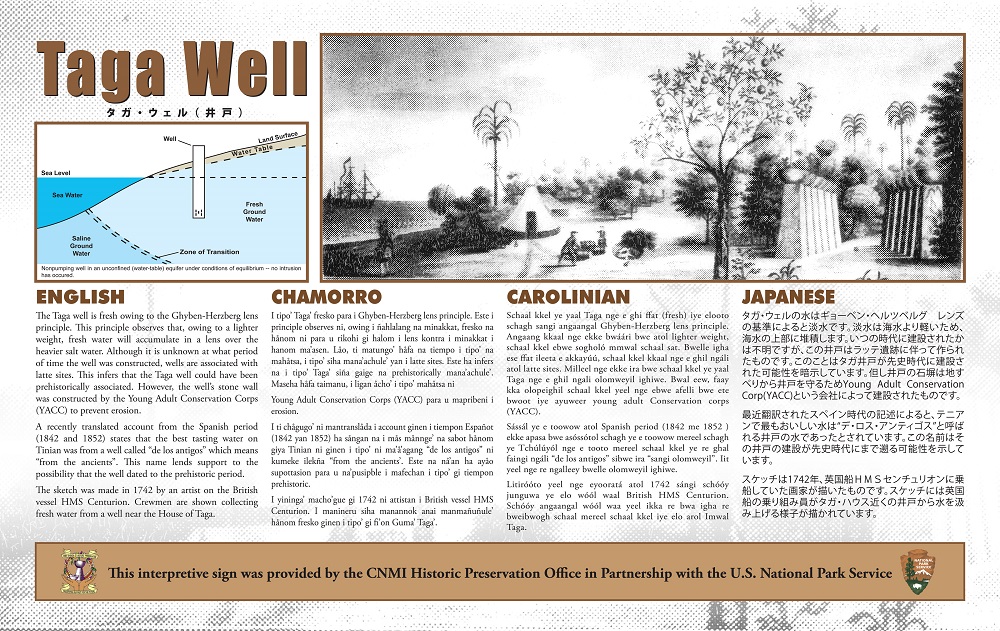
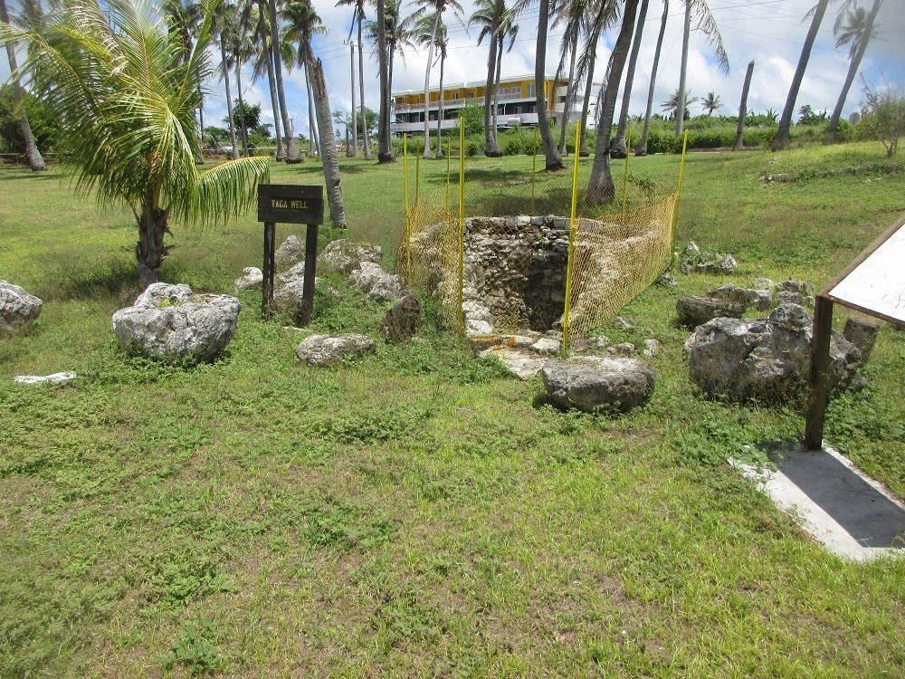
The Taga well is fresh owing to the Ghyben-Herzberg lens principle. This principle observes that, owing to a lighter weight, fresh water will accumulate in a lens over the heavier salt water. Although it is unknown at what period of time the well was constructed, wells are associated with latte sites. This infers that the Taga well could have been prehistorically associated. However, the well's stone wall was constructed by the Young Adult Conservation Corps (YACC) to prevent erosion.
A recently translated account from the Spanish period (1842 and 1852) states that the best tasting water on Tinian was from a well called "de los antigos" which means "from the ancients." This name lends support to the possibility that the well dated to the prehistoric period.
The sketch was made in 1742 by an artist on the British vessel HMS Centurion. Crewmen are shown collecting fresh water from a well near the House of Taga.
According to legend, this well was dug by Chief Taga and served as a fresh water source for his family. An English naval officer, Commodore George Anson, mentioned this well in a written account of his visit to Tinian in 1742. Anson tells of how one of his men fell into the well during a fight and drowned. The sides of the well are stone lined and, similar to other wells, dug into the coastal lowlands of Saipan, Tinian and Rota to reach a layer of fresh water that floats atop the denser seawater.
Taga Beach (Unai Taga)
(Slide 45 of 60 )(Swipe page or use arrows to navigate)
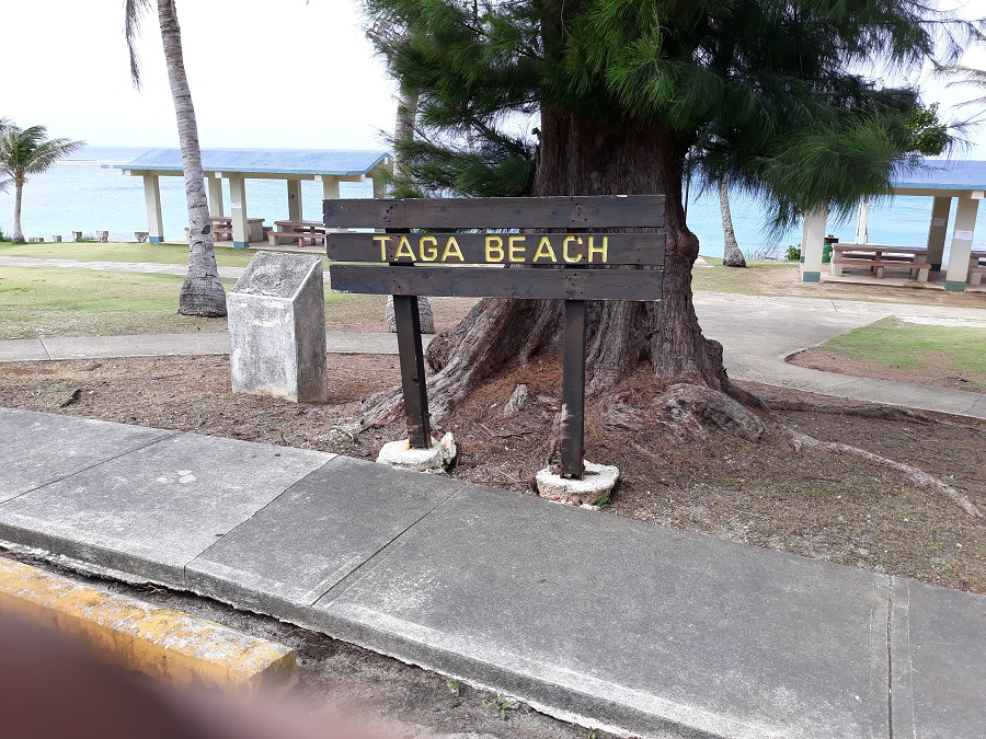
Unai Taga is located directly across from the Tinian Dynasty Hotel and Casino front entrance. The Unai Taga area is small and is accessed by a stairway system that extends to the beach and a concrete lookout area extending over the ocean where many local children enjoy diving and swimming. While the beach itself is quite small and generally frequented by residents, the site offers outstanding views to Aguijan Island and turquoise blue waters. It is a sightseeing stop for tourists.
Walk the beach
Tachogna Beach (Unai Tachogna)
(Slide 46 of 60 )(Swipe page or use arrows to navigate)
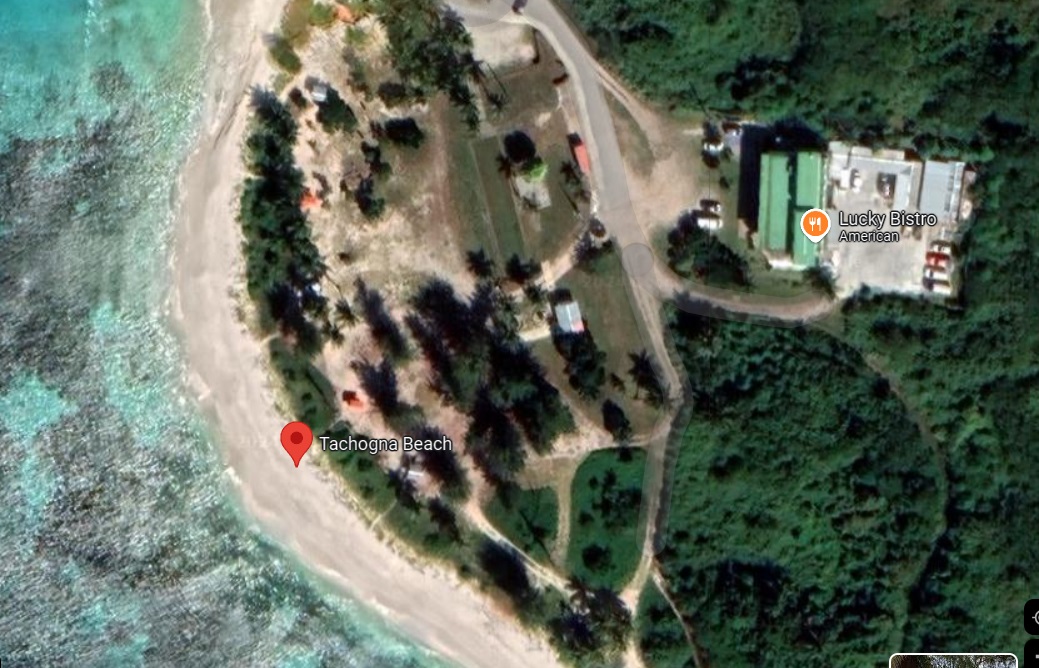
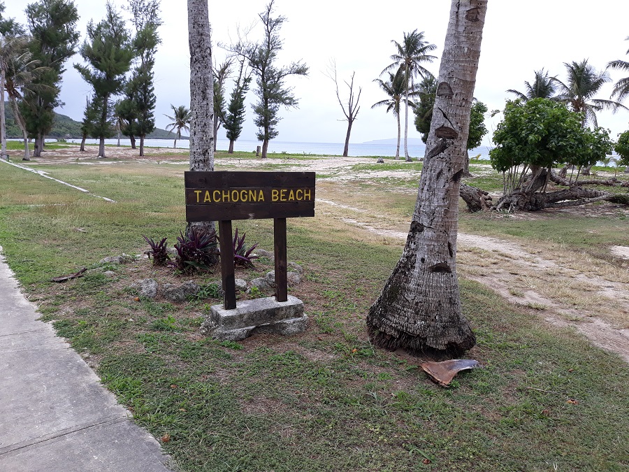
Unai Tachogna (Tachogna Beach) is located just south of Unai Taga and connected to it by a shoreline pathway. On weekends, local families and groups gather here to barbecue and picnic. It is also a popular place for snorkeling, personal watercraft, and banana boats, most of which can be rented from the beach operators. Like Unai Kammer, there are numerous covered pavilions for picnicking and socializing. This is often the spot of the annual Pika (hot pepper) Festival held in February!
Spanish Bell Tower
(Slide 47 of 60 )(Swipe page or use arrows to navigate)
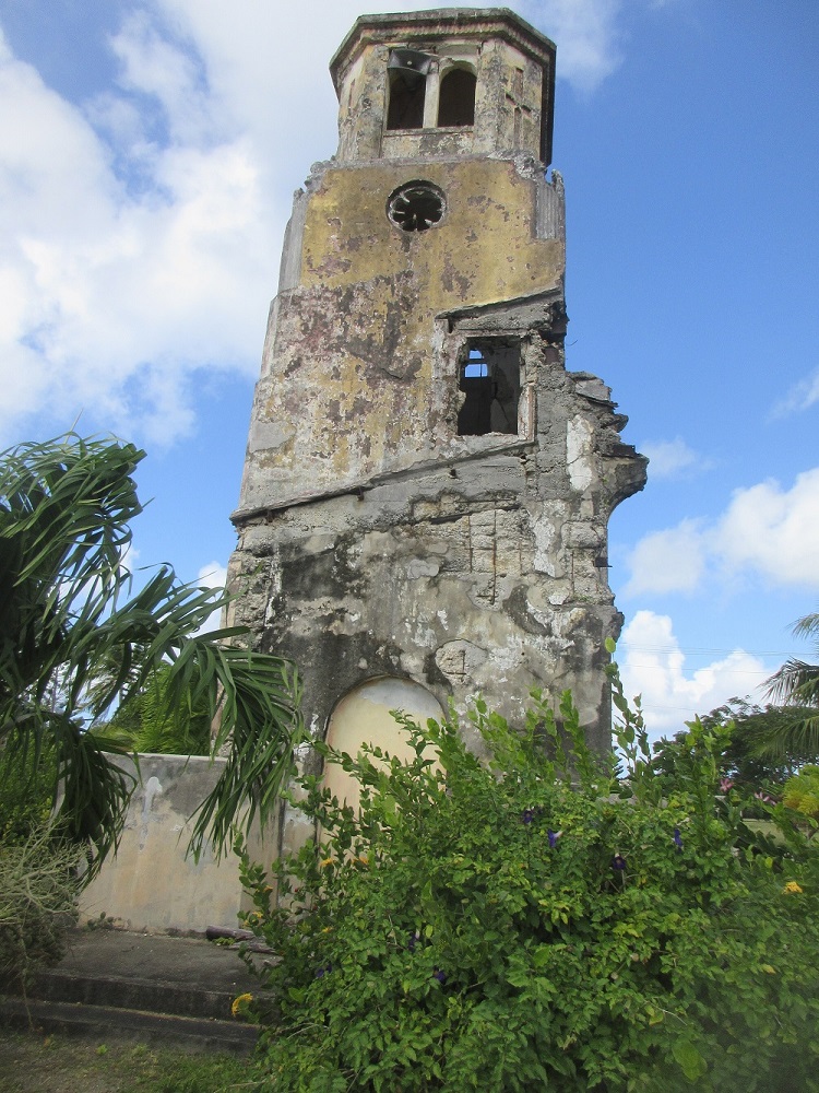
Tinian's Spanish Bell Tower has stood for over 100 years. The old San Jose Catholic Church was damaged during the Battle of Tinian, and the bell tower is all that remains.
Downtown San Jose
(Slide 48 of 60 )(Swipe page or use arrows to navigate)
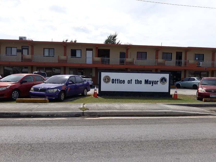
Mayor's office, fire station, library, schools, supermarkets, banks, post office...all within a three block strip!
Drive by!
Tinian Dynasty Hotel & Casino (Closed)
(Slide 49 of 60 )(Swipe page or use arrows to navigate)
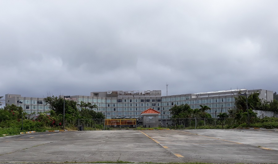
Once the largest employer on Tinian, the Dynasty Hotel and Casino now stands as a deteriorating relic and reminder of more prosperous times in the CNMI. The grounds are off limits, but you can still see remnants of its former opulence and grandeur.
Historical Preservation Office
(Slide 50 of 60 )(Swipe page or use arrows to navigate)
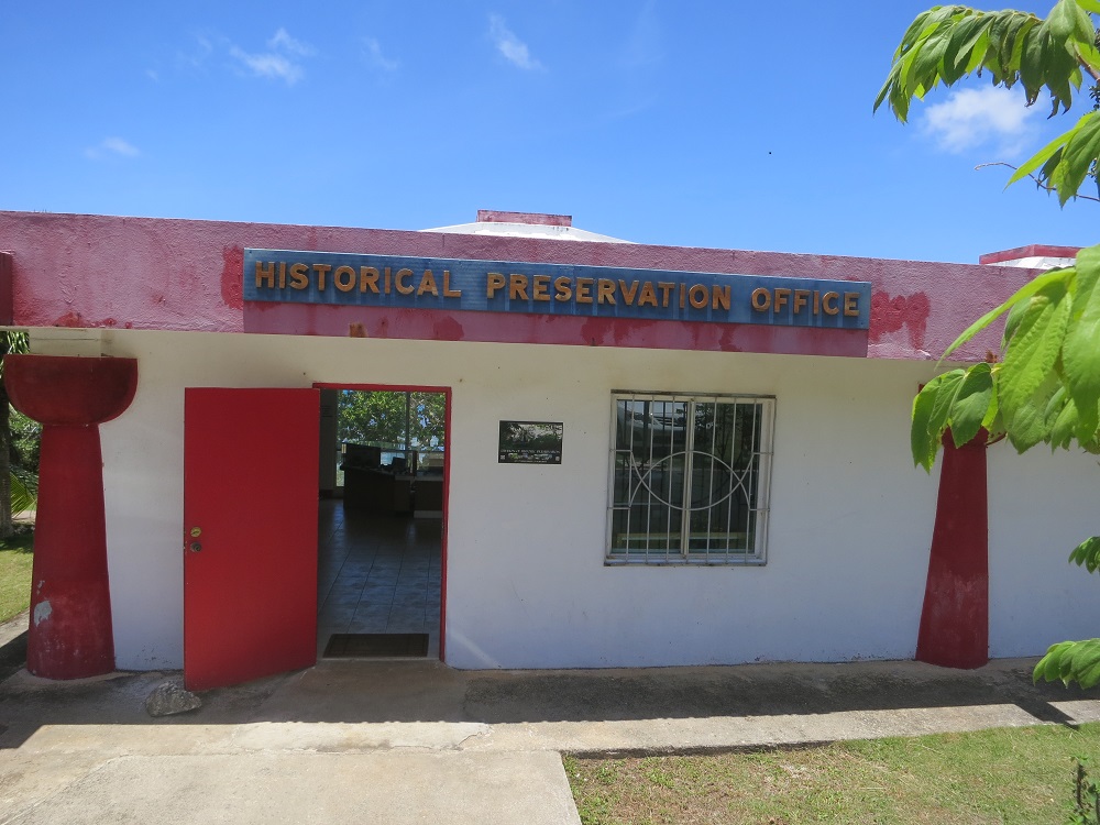
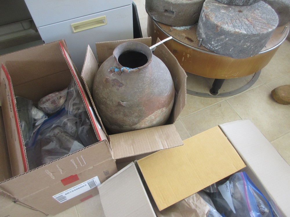
The CNMI Historic Preservation Office (HPO) is mandated under Public Law 3-39, cited as the “Commonwealth Historic Preservation Act of 1982,” to promote the preservation of the historic and cultural heritage of the Northern Mariana Islands and to prohibit the taking of historic properties and artifacts from the Northern Mariana Islands.
Located beach side opposite the Dynasty Hotel, the HPO is the island's repository of cultural artifacts. Be sure to stop by and take a look!
Little Boy and Fat Man
(Slide 51 of 60 )(Swipe page or use arrows to navigate)
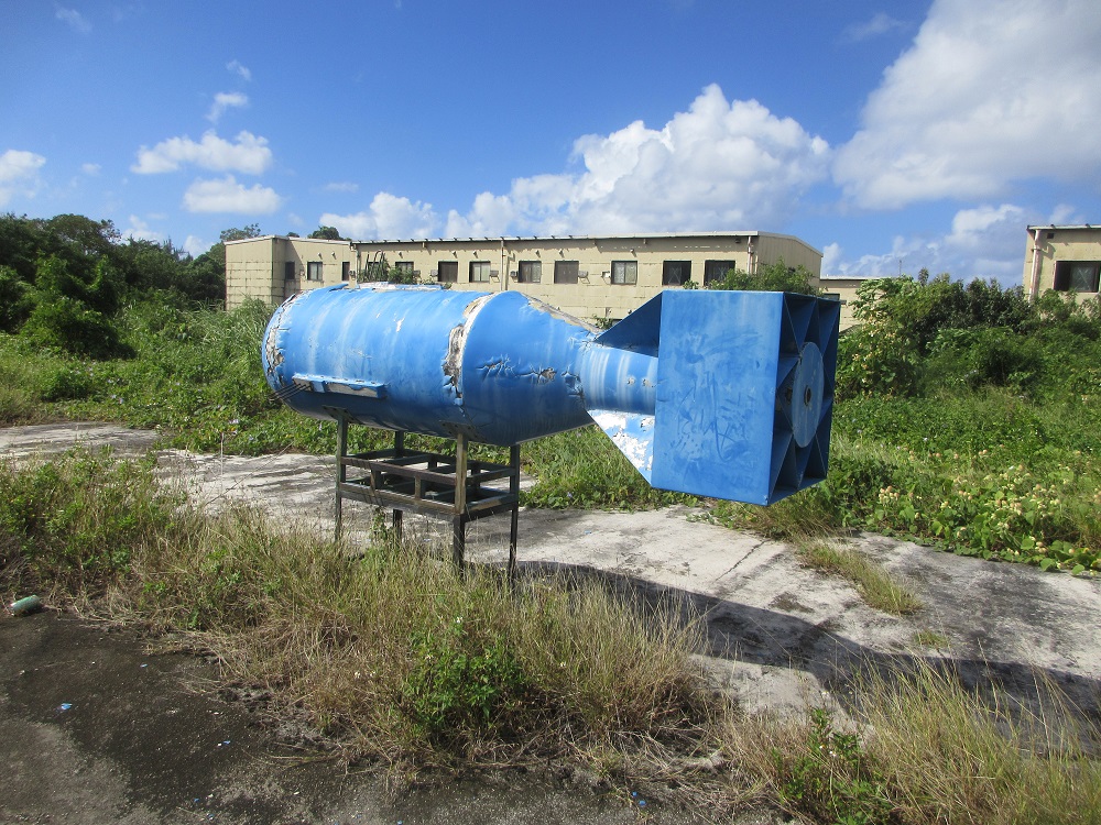
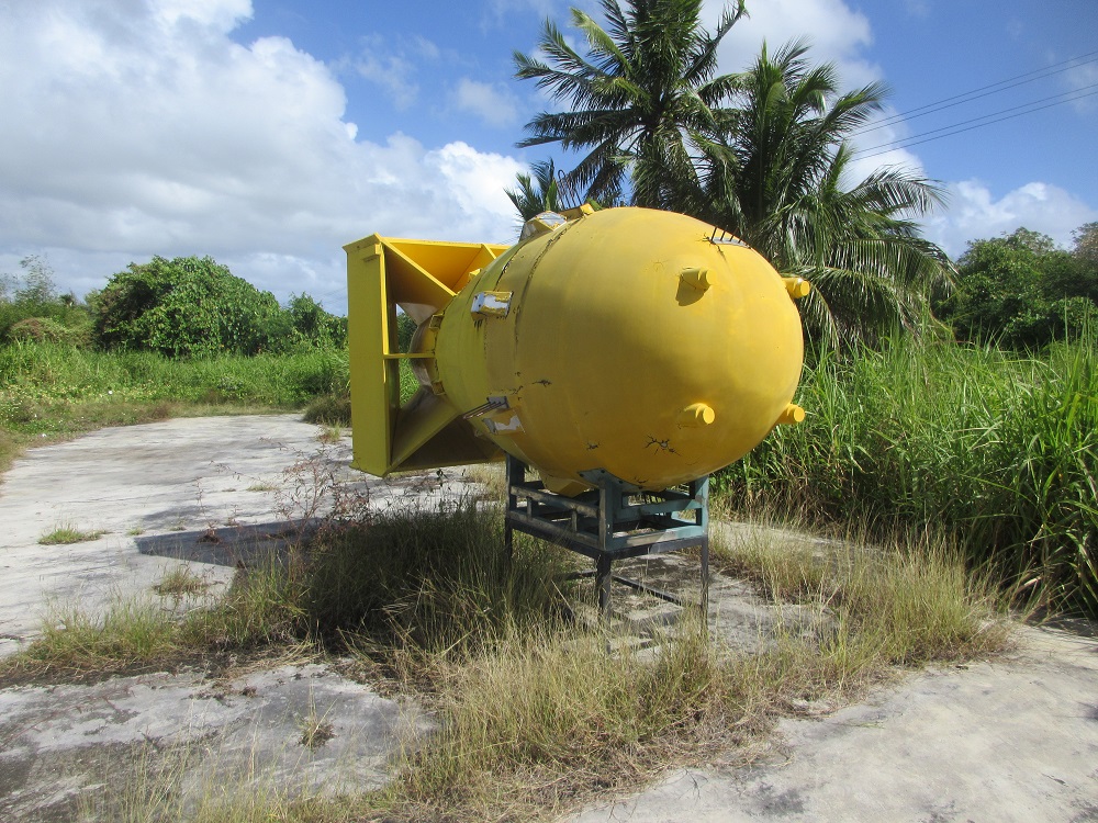
Actual Sized Replicas
Text of sign:"The first atomic bomb was made in the United States of America, the first batch consisting of three bombs: "Thin Man," "Fat Man" and "Little Boy." In 1939, just before the eruption of The Second World War, a team of chemists, led by Otto Hahn and Fritz Strassmann discovered that uranium and plutonium will undergo a chain reaction when the mass of fissionable material exceeds its critical mass, and thus a new explosive weapon could be detonated. Fearing that Hitler might use this new discovery to make a new weapon, a renowned physicist [Albert Einstein along with Leo Szilard] called for the signing of a letter suggesting to the U.S. government to support research of a uranium project.
"Under the advice of his trusted advisor, president Roosevelt approved a grant for the research of an atomic bomb project called The Manhattan Project. This project was carried out in New Mexico. After completion, "Thin Man" was successfully detonated in 1945. President Truman ordered the use of the bomb. A select team of civilians, Army Engineers, Army, Air Force and US Navy personnel were sent to Tinian to oversee the final field testing and successful delivery of the bomb.
"On August 6, 1945, the world's first atomic bomb, "Little Boy" was delivered from Tinian by an American B-29 bomber and dropped on the Japanese city of Hiroshima. Three days later, a seond bomb, "Fat Man," was supposed to be dropped on the city of Kokura. However, at the scheduled time of release, visibility over Kokura was minimal due to bad weather and the target could not be identified, so the plane continued to its secondary target, Nagasaki, and dropped the bomb. On August 14, Japan surrendered and World War II was finally over.
"The cities of Hiroshima and Nagasaki were destroyed. It is estimated that more than 445,000 people were killed by these two atomic bombs used in warfare."
Categories: World War II
Find it and explore
Limestone Forest Trail
(Slide 52 of 60 )(Swipe page or use arrows to navigate)
Enjoy a breathtaking view of Tinian harbor at this site. Take a trek on the trail to get even closer!
Categories: Nature
Suicide Cliff
(Slide 53 of 60 )(Swipe page or use arrows to navigate)

Suicide Cliff gets its name from the many Japanese civilians and military personnel that took their lives during the Battle of Tinian (DoN 2014). The cliff area contains a large paved parking area for cars and tour buses, as well as a comfort station. The center of the area contains bleachers facing a ceremonial area.
Sumiyoshi Shrine
(Slide 54 of 60 )(Swipe page or use arrows to navigate)
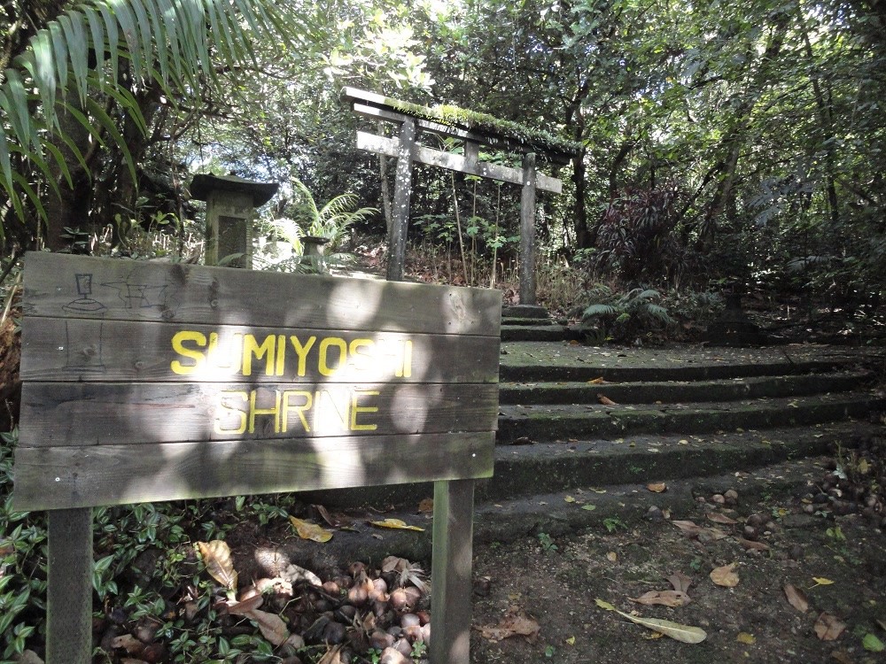
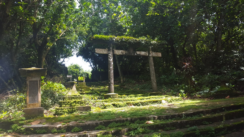
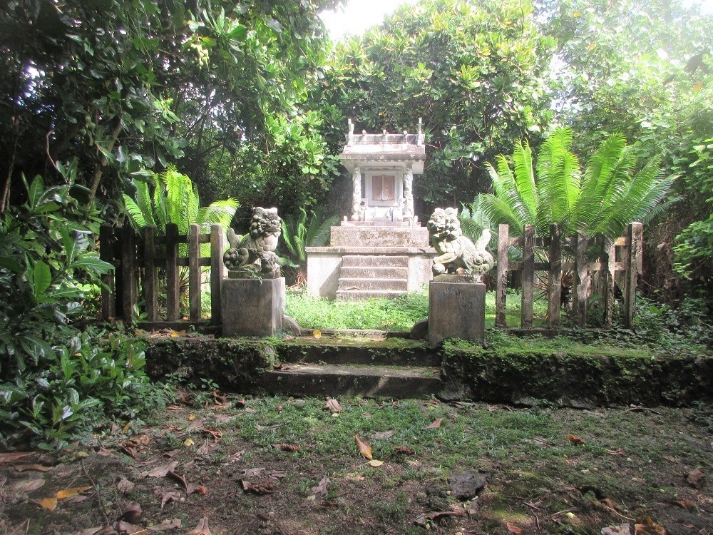
This well-preserved Shinto Shrine is one of the few authentic ones located outside Japan.
Explore
JC Café!
(Slide 55 of 60 )(Swipe page or use arrows to navigate)
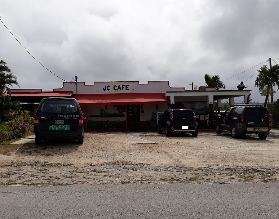
No tour of Tinian would be complete without a visit to this popular local restaurant! Be sure to mention that Walt sent you!!
Pika Festival
(Slide 56 of 60 )(Swipe page or use arrows to navigate)
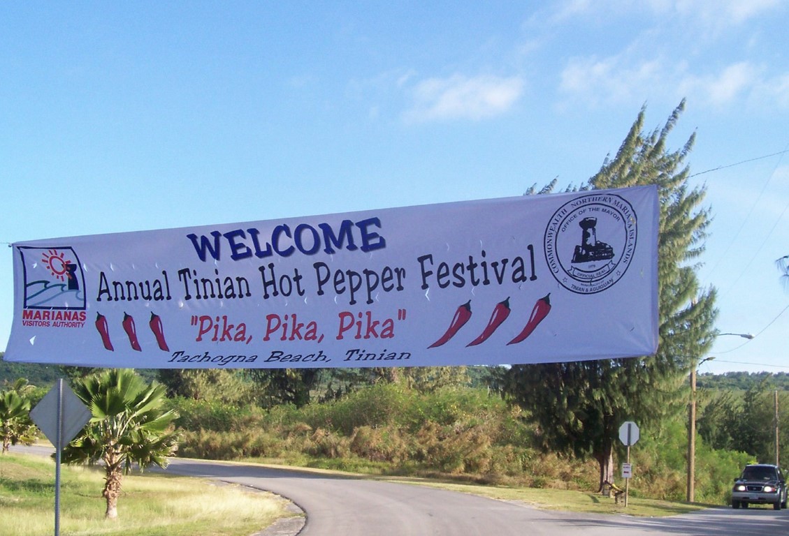
In February, the Tinian Mayor’s Office sponsors its annual 2-day Pika, or Hot Pepper, Festival to honor the Tinian hot pepper (Donni Sali), a small but hot native pepper. The festival is an island-style show that showcases a variety of locally prepared dishes, as well as arts and crafts. One of the highlights is the hot pepper eating contest. The festival location on Tinian varies from year to year (usually next to House of Taga or on Tachogna Beach), but the festival is always held in February over President’s Day weekend.
Other Annual Events
(Slide 57 of 60 )(Swipe page or use arrows to navigate)
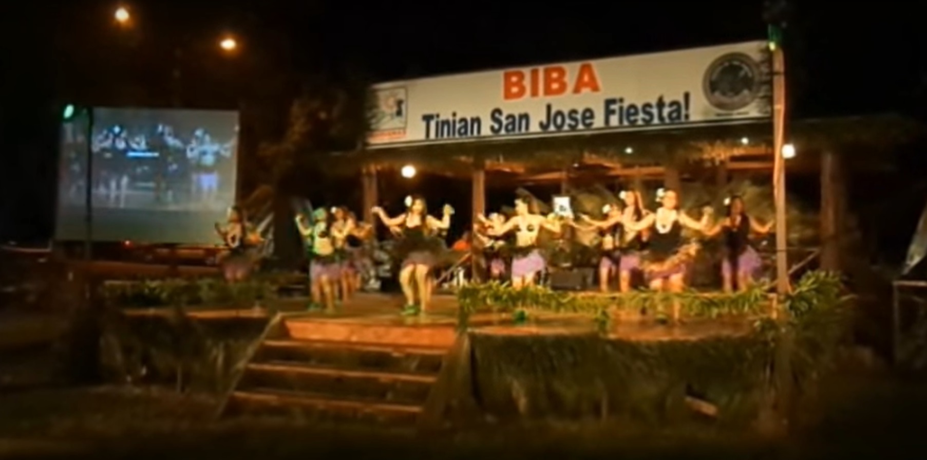
San Jose Fiesta
The San Jose Fiesta is an annual celebration of Tinian’s patron saint, hosted in May by the Mayor’s office at the Fiesta Grounds at Unai Kammer. The fiesta includes all night live entertainment, food and game concessions, carnival rides, big fish trolling competition, and a canoe race. The highlight of the fiesta is a community dinner banquet on Saturday following the Queen’s coronation. Sunday starts with the San Jose Mass followed by a continuation of the games at the fiesta grounds. Camp grounds are also provided for those who wish to tent camp.Tinian Turquoise Blue Triathlon and Reef Swim
The Tinian Turquoise Blue Triathlon and Reef Swim is co-sponsored by the Mariana Visitors Authority, KFC Triathlon Club of Japan, Tinian Mayor’s Office and features competitors from the CNMI and Japan. The triathlon course starts at Unai Taga with a 1.5 kilometer swim, transitions to a 40 kilometer bike ride in southern Tinian between the airport and Suicide Cliff, and finishes with a 10 kilometer run from Unai Taga to Suicide Cliff and back. There is also a 1.5, 3.0, and 4.5 kilometer reef swim at Unai Taga.
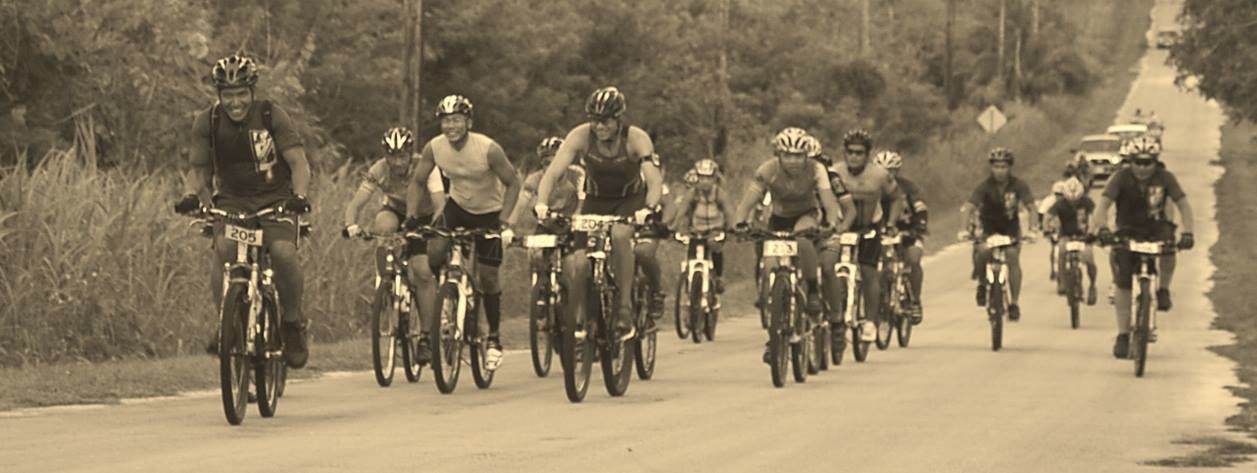
Tour de Tinian
The annual Tour de Tinian is a 100-kilometer mountain bike race through trails and dense vegetation hosted by the Bikers Association of Tinian. The race starts and ends in San Jose Village, and the race route includes interior and coastal areas in both north and south Tinian (i.e., within and outside of the Military Lease Area)
Videos from past events!
Your Adventure Continues!
(Slide 58 of 60 )(Swipe page or use arrows to navigate)
This may be the end of your "Tinian to Hiroshima" "King Taga" tour, but there's still much more to see and do here on Tinian: snorkeling, scuba diving, sky diving, fishing and more!
Your Private, Personalized Tour of Tinian!
(Slide 59 of 60 )(Swipe page or use arrows to navigate)

I'm not a member of the tourism establishment, so when you sign up for a personalized, private, off-the-beaten-path tour of Saipan or Tinian with me, you can ASK ME ANYTHING:
• The good, the bad & the ugly
• The untold truths
• The stories behind the headlines
• My personal experiences as a Jamaican on Saipan
• Things I'll only reveal "off the record"
Saipan-Specific Books!
(Slide 60 of 60 )(Swipe page or use arrows to navigate)


For all the commentary, trivia and facts that you didn't get from your local guide, pick up a copy of There's Something About Saipan (Tinian and Rota!)!
Categories: Chamorro/Carolinian/Pacific Culture, German era, Pre-war Japanese society, World War II, Contemporary CNMI life